Water Overlay Wizard: Difference between revisions
No edit summary |
No edit summary |
||
| (26 intermediate revisions by 4 users not shown) | |||
| Line 3: | Line 3: | ||
This configuration wizard is a special interface which helps to guide the configuration of a [[Water Overlay]]. Across multiple steps, it progresses through each type of [[GEO Data|Data]] which can be configured, along with the most important [[attribute]]s of the overlay. | This configuration wizard is a special interface which helps to guide the configuration of a [[Water Overlay]]. Across multiple steps, it progresses through each type of [[GEO Data|Data]] which can be configured, along with the most important [[attribute]]s of the overlay. | ||
{{Editor location|overlay wizard}} | {{Editor location|overlay wizard|Water Overlay}} | ||
Each of the | Each of the [[Water Overlay]] variants has a configuration wizard which helps the user with configuring the overlay. The general structure of the wizard is the same for all variants, with the exception that for [[Flooding_(Overlay)|flooding overlay]]s a step for configuring a [[Breach (Water Overlay)|breach]] area is included and for the [[Groundwater (Overlay)|groundwater overlay]]s a step for configuring an [[Aquifer (Water Overlay)|aquifer area]] is included. | ||
When the wizard has been completed once, it can be reopened at any time, and any step can be accessed anew. | When the wizard has been completed once, it can be reopened at any time, and any step can be accessed anew. | ||
| Line 16: | Line 16: | ||
[[File:FloodingOverlaySetUpWaterSystem1.jpg|thumb|200px|Step 2: Setup Water System]] | [[File:FloodingOverlaySetUpWaterSystem1.jpg|thumb|200px|Step 2: Setup Water System]] | ||
The water system is the most complex step of the configuration and contains a multitude of substeps to configure all geographical data. Its various components can be configured in the following order: | The water system is the most complex step of the configuration and contains a multitude of substeps to configure all geographical data. Its various components can be configured in the following order: | ||
: '''Breach''' (flooding overlays only): A breach area, a location where an (uncontrolled) inflow of water takes places. | : '''Breach''' (flooding overlays only): A [[Breach_(Water_Overlay)|breach area]], a location where an (uncontrolled) inflow of water takes places. | ||
: '''Water areas''': [[Water | : '''Water areas''': [[Water area (Water Overlay)|Water areas]], defined regions in which a specific water level is maintained. It is also possible to have the wizard generate a single water area for the entire project area. | ||
: '''Ground water''': [[ | : '''Ground water''': [[Ground model (Water Overlay)|Ground water]], supplied as the distance between the ground water level and the {{datum}}. A [[GeoTIFF]] can be [[Geo Data Wizard|imported]]. | ||
: '''Seepage''': [[Bottom pressure prequel (Water Overlay)|Bottom pressure]] and [[Bottom resistance prequel (Water Overlay)|resistance]], supplied as two prequel [[Grid Overlay]]s which can be [[Geo Data Wizard|imported]] ([[Groundwater Overlay]] only). | |||
: '''Sewers''': [[Sewer area (Water Overlay)|Sewer areas]], the broad definitions for where what kind of sewers exist. It is also possible to have the wizard generate sewer areas based on the [[neighborhood]]s in the project area. | : '''Sewers''': [[Sewer area (Water Overlay)|Sewer areas]], the broad definitions for where what kind of sewers exist. It is also possible to have the wizard generate sewer areas based on the [[neighborhood]]s in the project area. | ||
: '''Inundation areas''': [[Inundation area (Water Overlay)|Inundation areas]], definitions of water on the surface, in the form of inundated land. It is also possible to have the wizard generate a single inundation area covering the entire project area. | : '''Inundation areas''': [[Inundation area (Water Overlay)|Inundation areas]], definitions of water on the surface, in the form of inundated land. It is also possible to have the wizard generate a single inundation area covering the entire project area. | ||
: '''Aquifer areas''' ([[ | : '''Aquifer areas''' ([[Groundwater (Overlay)|groundwater overlays]] only): [[Aquifer (Water Overlay)|Aquifer areas]], definitions for transmissivity or hydraulic conductivity of the ground layer. | ||
: '''Weirs''': [[Weir (Water Overlay)|Weirs]], minor barriers in the water flow. | : '''Weirs''': [[Weir (Water Overlay)|Weirs]], minor barriers in the water flow. | ||
: '''Culverts''': Culvert (Water Overlay)|Culverts]], tunnels which form direct connections between two locations. | : '''Culverts''': [[Culvert (Water Overlay)|Culverts]], tunnels which form direct connections between two locations. | ||
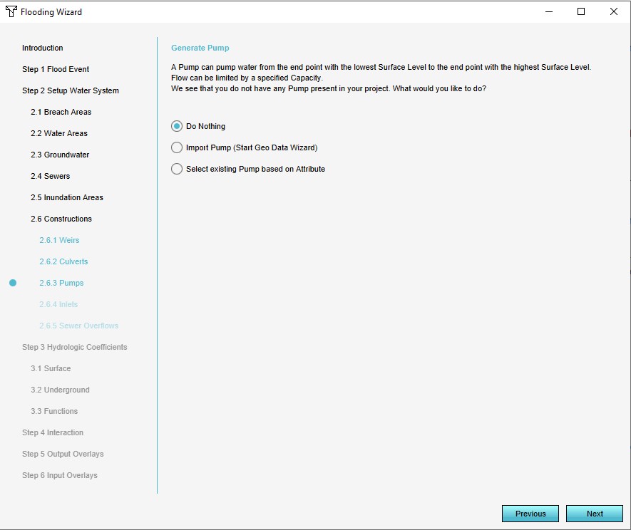
: '''Pumps''': [[Pump (Water Overlay)|Pumps]], structures which move water from a lower to a higher location. | : '''Pumps''': [[Pump (Water Overlay)|Pumps]], structures which move water from a lower to a higher location. | ||
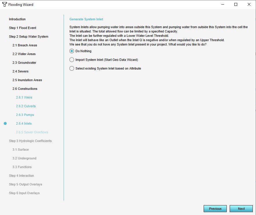
: '''Inlets''': [[Inlet (Water Overlay)|Inlets]], structures which add or remove water. | : '''Inlets''': [[Inlet (Water Overlay)|Inlets]], structures which add or remove water. | ||
| Line 34: | Line 35: | ||
File:FloodingOverlayWizardWaterAreas1.jpg|Water Areas | File:FloodingOverlayWizardWaterAreas1.jpg|Water Areas | ||
File:FloodingOverlayWizardGroundWater1.jpg|Ground Water | File:FloodingOverlayWizardGroundWater1.jpg|Ground Water | ||
File:Seepage_wizard.jpg|Seepage | |||
File:FloodingOverlayWizardSewers1.jpg|Sewers | File:FloodingOverlayWizardSewers1.jpg|Sewers | ||
File:FloodingOverlayWizardInundationAreas1.jpg|Inundation Areas | File:FloodingOverlayWizardInundationAreas1.jpg|Inundation Areas | ||
| Line 43: | Line 45: | ||
File:FloodingOverlayWizardSewerOverflows1.jpg|Sewer Overflows | File:FloodingOverlayWizardSewerOverflows1.jpg|Sewer Overflows | ||
</gallery> | </gallery> | ||
{{clear}} | |||
===Feedback=== | |||
In the Water Overlay Wizard you can encounter several of the components highlighted yellow (warning) or red (error). This feedback is provided to help you configure the modelled water system to make it fully functional in the {{software}} and provide information about the configured settings and imported data. Any errors in the imported data for example will be highlighted. | |||
When selecting a step which is highligthed yellow or red, the drop-down menu will automatically place the warnings and errors at the top of the menu. When selecting one of these from the menu, feedback about the warning or error is displayed in the wizard. | |||
To solve these issues, possible fixes are proposed which can be automatically applied when accepted. The possible fixes are depicted with the tool icon. By clicking on this icon, the fix is proposed and can be applied. <br> | |||
See also [[How to apply fixes for multiple components in the Water Overlay Wizard]]. | |||
[[File:Warning_in_wizard.PNG|left|400px|Warning in the wizard]] | |||
{{clear}} | {{clear}} | ||
| Line 49: | Line 59: | ||
Hydrological coefficients are values of existing elements of the world, specifically [[Terrain|terrain]] and [[Hydrological attributes of constructions (Water Overlay)|constructions]]. The coefficients dictate the ability of water to flow between cells and layers. The following data can be configured: | Hydrological coefficients are values of existing elements of the world, specifically [[Terrain|terrain]] and [[Hydrological attributes of constructions (Water Overlay)|constructions]]. The coefficients dictate the ability of water to flow between cells and layers. The following data can be configured: | ||
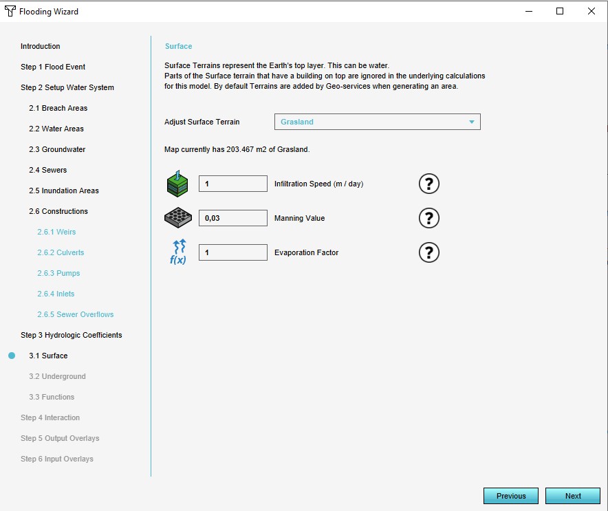
: '''Surface terrain''': For the surface terrains, attributes can be adjusted directly. | : '''Surface terrain''': For the surface terrains, attributes can be adjusted directly. | ||
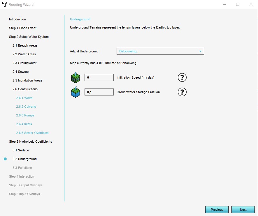
: ''' | : '''Ground terrain''': For the ground terrains, attributes can be adjusted directly as well. | ||
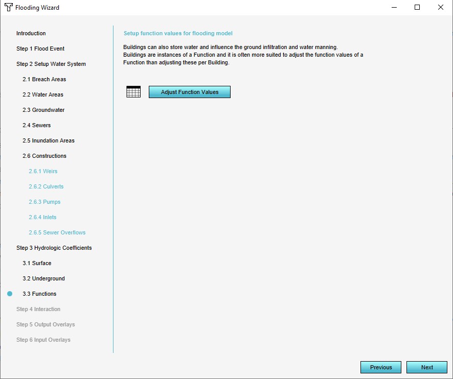
: '''Constructions''': For constructions, the wizard links to the [[Functions#Function values|function values]] editing screen, and will open with focus on "WATER" related functions. | : '''Constructions''': For constructions, the wizard links to the [[Functions#Function values|function values]] editing screen, and will open with focus on "WATER" related functions. | ||
<gallery widths=75px heights=75px> | <gallery widths=75px heights=75px> | ||
File:FloodingOverlayWizardSurfaceTerrain1.jpg|Surface terrain | File:FloodingOverlayWizardSurfaceTerrain1.jpg|Surface terrain | ||
File:FloodingOverlayWizardUndergroundTerrain1.jpg| | File:FloodingOverlayWizardUndergroundTerrain1.jpg|Ground terrain | ||
File:FloodingOverlayWizardConstructions1.jpg|Constructions | File:FloodingOverlayWizardConstructions1.jpg|Constructions | ||
</gallery> | </gallery> | ||
| Line 60: | Line 70: | ||
===Step 4: Interaction=== | ===Step 4: Interaction=== | ||
[[File:FloodingOverlayWizardInteraction1.jpg|thumb|200px|Step 4: Interaction]] | [[File:FloodingOverlayWizardInteraction1.jpg|thumb|200px|Step 4: Interaction]] | ||
The wizard provides a few options to automatically generate methods of interaction with the hydrological model. The [[ | The wizard provides a few options to automatically generate methods of interaction with the hydrological model. The [[System_visualization_(Water_Overlay)|system visualization]] can be activated or deactivated. Additionally, for some hydrological constructions and features panels can be generated which allow for their most important attributes during a [[session]].<!-- | ||
: '''System visualisation''': | : '''System visualisation''': | ||
: '''Interaction panels''': | : '''Interaction panels''': | ||
| Line 70: | Line 80: | ||
Multiple [[Result type (Water Overlay)|result types]] are available. In the wizard multiple result types can be selected. One result type (indicated with the "First" checkbox) will be the main overlay's result type. The other selections will become [[Result type (Water Overlay)#Multiple result child overlays|result type child overlays]]. Relevant attributes can be modified as well, if they are related to selected result types. | Multiple [[Result type (Water Overlay)|result types]] are available. In the wizard multiple result types can be selected. One result type (indicated with the "First" checkbox) will be the main overlay's result type. The other selections will become [[Result type (Water Overlay)#Multiple result child overlays|result type child overlays]]. Relevant attributes can be modified as well, if they are related to selected result types. | ||
Finally, the [[Timeframes | Finally, the [[Timeframes (Water Overlay)|TIMEFRAMES]] attribute can be configured here as well, defining the amount of result snapshots which should be made during the calculation. | ||
{{clear}} | {{clear}} | ||
| Line 77: | Line 87: | ||
To gain more insight into the data used by the model, you may opt to add one or more [[input overlay]]s as well. These add [[Average Overlay]]s that are configured for the geographical display of attribute values relevant for the calculation of the water model. | To gain more insight into the data used by the model, you may opt to add one or more [[input overlay]]s as well. These add [[Average Overlay]]s that are configured for the geographical display of attribute values relevant for the calculation of the water model. | ||
{{clear}} | {{clear}} | ||
[[Category:Wizards]] | |||
Latest revision as of 15:41, 26 January 2024

This configuration wizard is a special interface which helps to guide the configuration of a Water Overlay. Across multiple steps, it progresses through each type of Data which can be configured, along with the most important attributes of the overlay.
Each of the Water Overlay variants has a configuration wizard which helps the user with configuring the overlay. The general structure of the wizard is the same for all variants, with the exception that for flooding overlays a step for configuring a breach area is included and for the groundwater overlays a step for configuring an aquifer area is included.
When the wizard has been completed once, it can be reopened at any time, and any step can be accessed anew.
Step 1: Weather

The weather event defines the total simulation time and the weather and climate effects during the simulation. Specifically, the amount of rain and when it falls during the simulation, as well as the evaporation which takes place
Step 2: Water system

The water system is the most complex step of the configuration and contains a multitude of substeps to configure all geographical data. Its various components can be configured in the following order:
- Breach (flooding overlays only): A breach area, a location where an (uncontrolled) inflow of water takes places.
- Water areas: Water areas, defined regions in which a specific water level is maintained. It is also possible to have the wizard generate a single water area for the entire project area.
- Ground water: Ground water, supplied as the distance between the ground water level and the datum. A GeoTIFF can be imported.
- Seepage: Bottom pressure and resistance, supplied as two prequel Grid Overlays which can be imported (Groundwater Overlay only).
- Sewers: Sewer areas, the broad definitions for where what kind of sewers exist. It is also possible to have the wizard generate sewer areas based on the neighborhoods in the project area.
- Inundation areas: Inundation areas, definitions of water on the surface, in the form of inundated land. It is also possible to have the wizard generate a single inundation area covering the entire project area.
- Aquifer areas (groundwater overlays only): Aquifer areas, definitions for transmissivity or hydraulic conductivity of the ground layer.
- Weirs: Weirs, minor barriers in the water flow.
- Culverts: Culverts, tunnels which form direct connections between two locations.
- Pumps: Pumps, structures which move water from a lower to a higher location.
- Inlets: Inlets, structures which add or remove water.
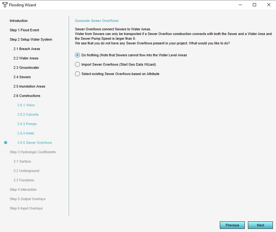
- Sewer overflows: Sewer overflows, points where water from sewers can flow back onto the surface.
All of the above components can be imported or connected to the hydrological model.
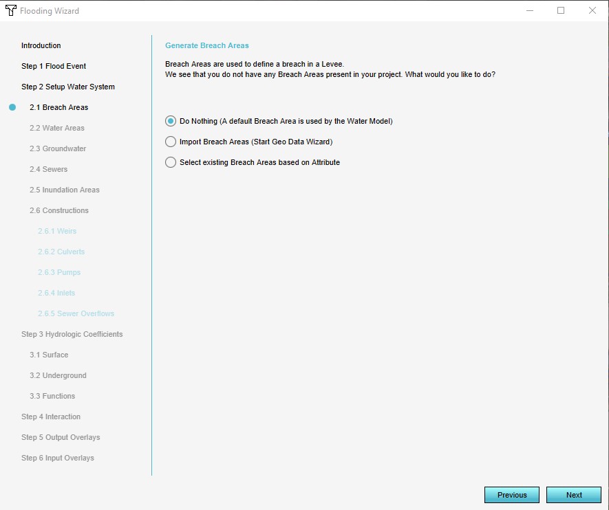
Breach Area
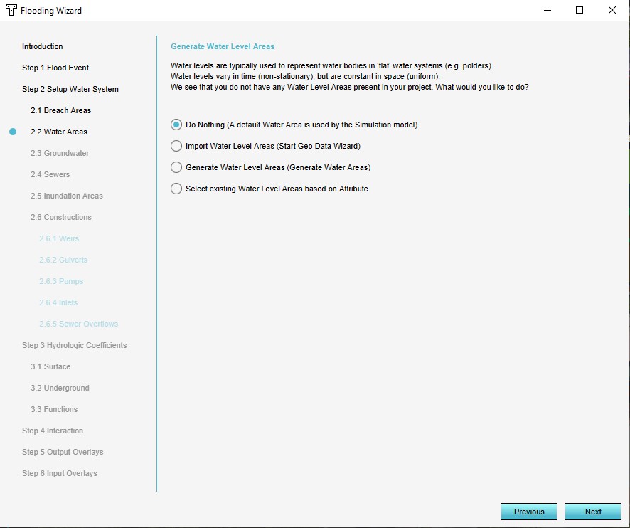
Water Areas
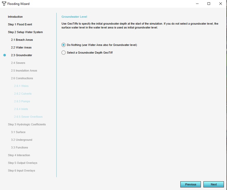
Ground Water

Seepage
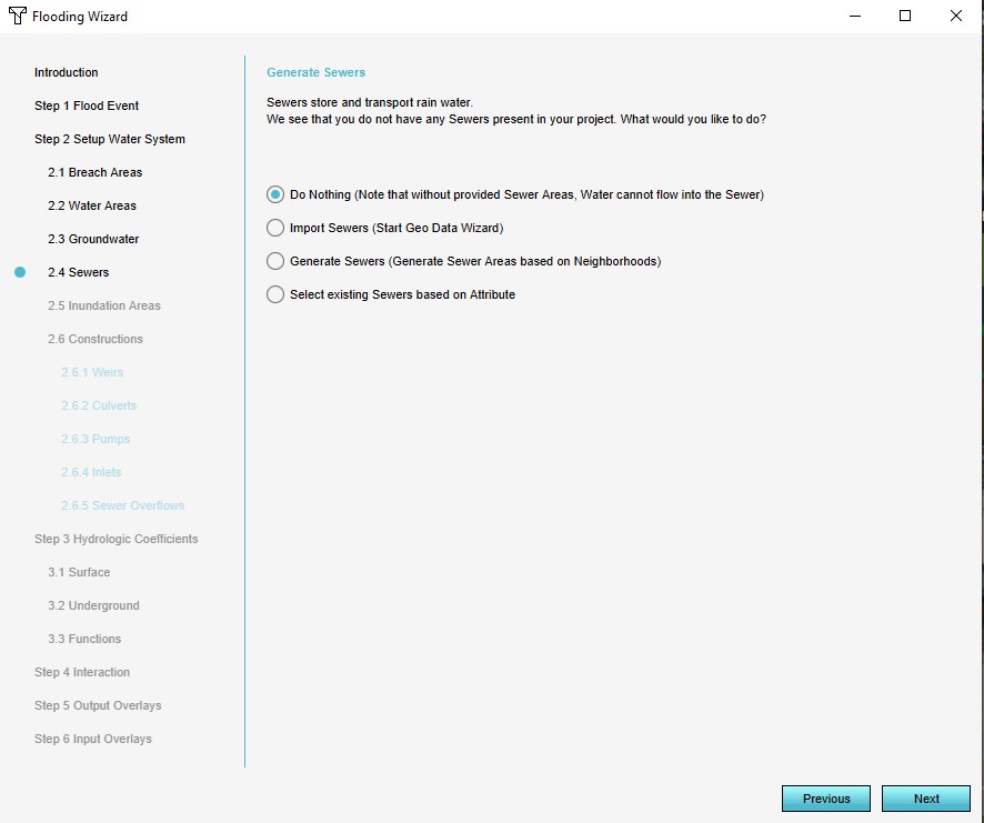
Sewers
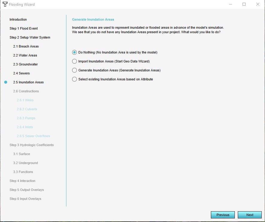
Inundation Areas
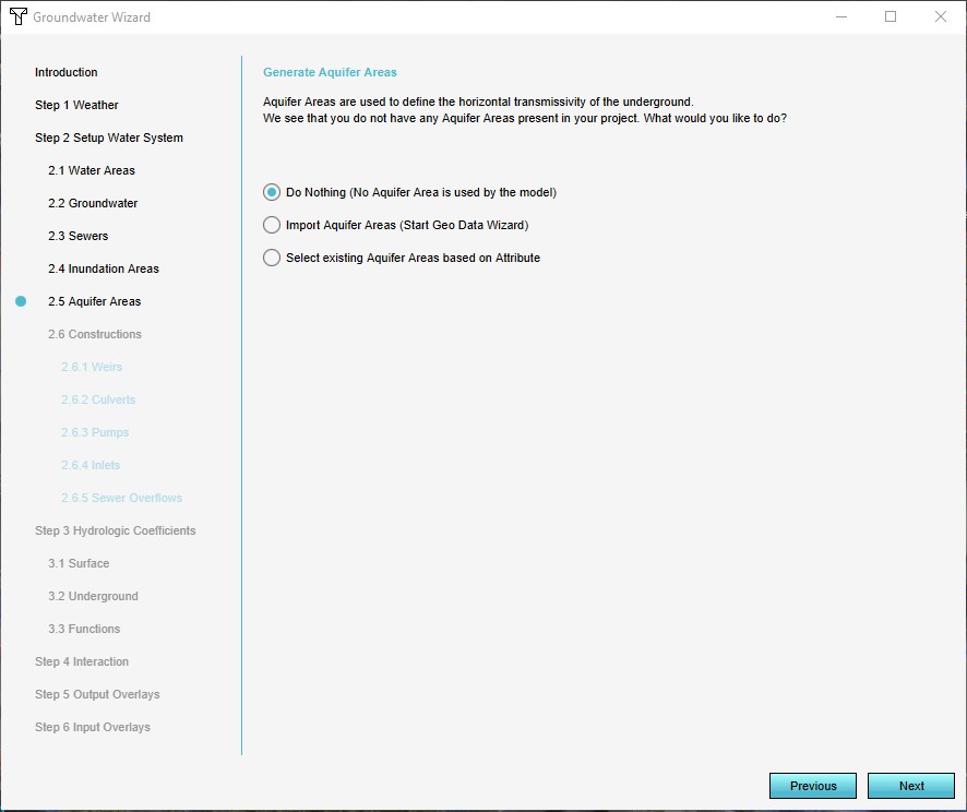
Aquifer Areas
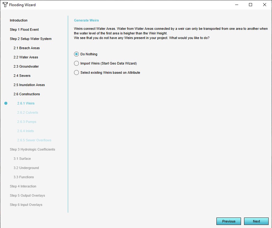
Weirs
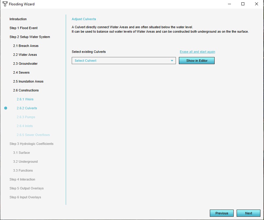
Culverts
Pumps
Inlets
Sewer Overflows


Feedback
In the Water Overlay Wizard you can encounter several of the components highlighted yellow (warning) or red (error). This feedback is provided to help you configure the modelled water system to make it fully functional in the Tygron Platform and provide information about the configured settings and imported data. Any errors in the imported data for example will be highlighted.
When selecting a step which is highligthed yellow or red, the drop-down menu will automatically place the warnings and errors at the top of the menu. When selecting one of these from the menu, feedback about the warning or error is displayed in the wizard.
To solve these issues, possible fixes are proposed which can be automatically applied when accepted. The possible fixes are depicted with the tool icon. By clicking on this icon, the fix is proposed and can be applied.
See also How to apply fixes for multiple components in the Water Overlay Wizard.

Step 3: Hydrological coefficients

Hydrological coefficients are values of existing elements of the world, specifically terrain and constructions. The coefficients dictate the ability of water to flow between cells and layers. The following data can be configured:
- Surface terrain: For the surface terrains, attributes can be adjusted directly.
- Ground terrain: For the ground terrains, attributes can be adjusted directly as well.
- Constructions: For constructions, the wizard links to the function values editing screen, and will open with focus on "WATER" related functions.
Surface terrain
Ground terrain
Constructions


Step 4: Interaction

The wizard provides a few options to automatically generate methods of interaction with the hydrological model. The system visualization can be activated or deactivated. Additionally, for some hydrological constructions and features panels can be generated which allow for their most important attributes during a session.
Step 5: Output overlays

Multiple result types are available. In the wizard multiple result types can be selected. One result type (indicated with the "First" checkbox) will be the main overlay's result type. The other selections will become result type child overlays. Relevant attributes can be modified as well, if they are related to selected result types.
Finally, the TIMEFRAMES attribute can be configured here as well, defining the amount of result snapshots which should be made during the calculation.
Step 6: Input overlays

To gain more insight into the data used by the model, you may opt to add one or more input overlays as well. These add Average Overlays that are configured for the geographical display of attribute values relevant for the calculation of the water model.