UK Benchmark 1 (Water Module): Difference between revisions
No edit summary |
|||
| Line 2: | Line 2: | ||
==Description== | ==Description== | ||
[[File:Sloping_topography_ukbm.png|right]] | [[File:Sloping_topography_ukbm.png|right|Sloping topography with depression]] | ||
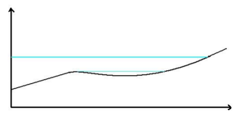
''This test consists of a sloping topography with a depression as illustrated in the Figure on the right. An inflow boundary condition is applied at the low end, causing the water to rise to the level indicated by a thick blue line. The inflow is then replaced by a sink term until the water level becomes as indicated by the thin blue line. A similar test has been used by EDF (2000) for validation of the TELEMAC package.'' | ''This test consists of a sloping topography with a depression as illustrated in the Figure on the right. An inflow boundary condition is applied at the low end, causing the water to rise to the level indicated by a thick blue line. The inflow is then replaced by a sink term until the water level becomes as indicated by the thin blue line. A similar test has been used by EDF (2000) for validation of the TELEMAC package.'' | ||
==Technical setup== | ==Technical setup== | ||
The provided ascii height file named test1DEM.asc is first imported. It has a cell size of 2m, while the test is expected to run on a 10m grid. Therefore, it will be automatically rescaled by the [[Grid Rasterizer|grid rasterizer]]. The resulting rescaled asc file is packed in the {{anchor|test case zip}} down below. | The provided ascii height file named test1DEM.asc is first imported. It has a cell size of 2m, while the test is expected to run on a 10m grid. Therefore, it will be automatically rescaled by the [[Grid Rasterizer|grid rasterizer]]. The resulting rescaled asc file is packed in the {{anchor|test case zip}} down below. | ||
Revision as of 08:12, 17 April 2019
This page contains the test case 1 of the UK benchmark named Test 1 – Uncovering of a beach as well as its result generated by the Water Module in the Tygron Platform.
Description

This test consists of a sloping topography with a depression as illustrated in the Figure on the right. An inflow boundary condition is applied at the low end, causing the water to rise to the level indicated by a thick blue line. The inflow is then replaced by a sink term until the water level becomes as indicated by the thin blue line. A similar test has been used by EDF (2000) for validation of the TELEMAC package.
Technical setup
The provided ascii height file named test1DEM.asc is first imported. It has a cell size of 2m, while the test is expected to run on a 10m grid. Therefore, it will be automatically rescaled by the grid rasterizer. The resulting rescaled asc file is packed in the down below.