Watershed Module overview
Overview

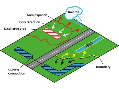
The watershed module calculates discharge areas for rainfall based on a digital terrain model or a calculated flow direction result of a Water Overlay. The Watershed Overlay can provide an indication into which water body rainfall will end up. Users can assign and group water bodies using discharge areas as input data. Additionally, culverts that connect water bodies can be taken into account, which enables smaller water bodies to be assigned to provided discharge areas.
Input
- Water terrains
- Discharge areas (Advised)
- Either:
- Water Overlay's surface flow direction result type;
- Digital terrain model (DTM).
- Culverts (Optional)
Options
- Discharge remaining water: Create additional discharge areas for water bodies that are not connected by culverts to discharge areas.
- Minimal area: Only water bodies with the required minimum size can become an additional discharge areas.
- Discharge method:
- Height minima: Restricted to height map input data
- Water terrains: Restricted to directional data. Each water body is a separate discharge area.
- Specific areas: Restricted to directional data. Water body cells that intersect with a specified discharge area are assigned to that area. Water bodies that are connected by culverts to discharge area water bodies are assigned to that discharge area as well. Depending on the option "Discharge remaining water", the remaining water bodies are stored as a separate discharge area.
- Fill distance: unmatched cells are assigned to nearest found discharge area when within the provided distance.
- Culvert flow direction: When active, a water body is only connected to an other water body when the first flows to the second.


