Density indicators
General
What are the Density indicators?
The Density indicators exist out of three indices that define density in an area. These are:
- FSI - Floor Space Index or Floor Area Ration; which gives information about the intensity of the buildings in relation to the open space. The higher the index is, the more buildings and/or floors there are.
- GSI - Ground Space Index; which gives information about the relation between built and open space. The lower the index is, the more open space there is in the area.
- OSR - Open Space Ration; which gives information about the spaciousness and pressure on the open space. A high FSI ensures a low OSR. The higher the OSR is, the more open space there is.
This indicator is useful for projects where for example:
- Density analysis is an important aspect of the project
- A new neighborhood is designed
For a Parametric Design these density indicators are automatically calculated.
Indicator panel

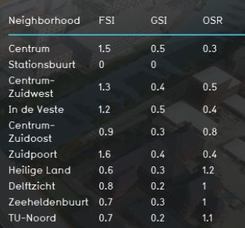
The indicator panel shows per neighborhood:
- The neighborhood name
- FSI score
- GSI score
- OSR score
Each of these indices is also added as an attribute to the neighborhoods. These attributes can then be used for visualizing the scores in a map. See the additional configurations for the steps.
Calculation
The calculation for the indices is as follows:
- FSI = Floorspace (floorspace) / landsize neighborhood
- GSI = Lotsize (footprint) / landsize neighborhood
- OSR = (1-GSI) / FSI
For the calculation of the indices, you can look at it at different scales: plot, building block, neighborhood, district and municipality. For this calculation the neighborhood is chosen. It is possible to change the indicator to calculate on another scale or add a new neighborhood to your project which consists of your plan area.
For a Parametric Design these density indicators are automatically calculated. The scale for this is the design area. For example, the FSI is then calculated by: Floorspace / landsize of the design area.
Note: the Functions which are buildings in the Tygron Platform are determined by the value of MAX_FLOORS. If the value of the MAX_FLOORS attribute is >1, the function is considered to be a building and is included in calculating the lotsize and floorspace. This approach is chosen to keep the Excel file simple and scalable when new building functions are added by duplicating existing functions. However, a few building functions are not included by this approach such as the convenience store (buurtwinkel), cattle farm (veehouderij) en gas station (tankstation). If these functions are used in your project, the Excel can be easily extended with queries regarding these functions.
Score
For this indicator no score is being calculated. The progress bar shows always 100% (fixed number).
Additional configurations
For this indicator to function, no additional configurations are needed. However, extra Overlays can be made to make the indicator also visual in a map. Below the steps on how to create the overlay:
- Select the Current situation tab and hover over Overlays in the ribbon header
- Add the Avg overlay
- In the right panel, give the overlay the name FSI
- Click on the Configuration Wizard
- Choose: gain insight into grid cell values
- Click on select and choose the FSI attribute
- Choose Specific layer only and then the neighborhood layer
- Finish the wizard
- Now the overlay is created
- Follow the same steps for the GSI and OSR overlay.