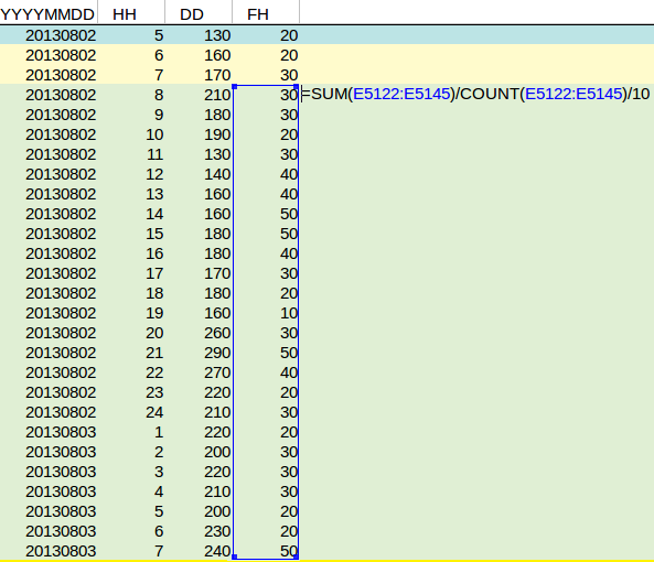
How to calculate the daily average wind speed
The daily average wind speed has to be measured from 8 UTC current day to 7 UTC the next day, according to the DPRA Heat stress report. The wind speed is also measured in 0.1 meters, so the values from the KNMI weather data column FH have to be divided by 10 to get to a value in m/s.
| Column | Name | Unit | Dutch Description |
|---|---|---|---|
| 2/B | YYYYMMDD | Date | datum (YYYY=jaar,MM=maand,DD=dag) |
| 3/C | HH | Hour | tijd (HH=uur, UT.12 UT=13 MET, 14 MEZT. Uurvak 05 loopt van 04.00 UT tot 5.00 UT |
| 4/D | DD | Degrees | Windrichting (in graden) gemiddeld over de laatste 10 minuten van het afgelopen uur (360=noord, 90=oost, 180=zuid, 270=west, 0=windstil 990=veranderlijk. Zie http://www.knmi.nl/kennis-en-datacentrum/achtergrond/klimatologische-brochures-en-boeken |
| 5/E | FH | 0.1 m/s | Uurgemiddelde windsnelheid (in 0.1 m/s). Zie http://www.knmi.nl/kennis-en-datacentrum/achtergrond/klimatologische-brochures-en-boeken |
Notes
- The values at each hour regard the measurement over the preceding hour up to that time. To obtain the value for august 2nd, the values at 8am of august 2nd, up to and including 7am on august 3rd must be used.
- The wind speed (hourly, and daily average) can also be based on an other data source; Potentiele wind (UP): http://projects.knmi.nl/klimatologie/onderzoeksgegevens/potentiele_wind-sigma/. These values are often a few 0.1 m/s higher than the values from the historical KNMI weather data table.
