Climate adaptation (Indicator): Difference between revisions
No edit summary |
No edit summary |
||
| Line 18: | Line 18: | ||
===Calculation=== | ===Calculation=== | ||
The calculation on if a neighborhood is cool enough is can be read here [[Heat_(Overlay)#Calculations|section]]. If a neighborhood has enough green is calculated by comparing the amount of m² green (grassland, open land and dunes) to the amount of m² total land. If the neighborhood has enough water storage is calculated by comparing the amount of m² terrain with water storage to the amount of m² total land. | The calculation on if a neighborhood is cool enough is can be read here [[Heat_(Overlay)#Calculations|section]]. If a neighborhood has enough green is calculated by comparing the amount of m² green (grassland, open land and dunes) to the amount of m² total land. To reach a score of 100% on green enough, an area needs to consist of 20% green. This percentage can be changed in the excel file. If the neighborhood has enough water storage is calculated by comparing the amount of m² terrain with water storage to the amount of m² total land. To reach a score of 100% of enough water storage, an area needs to consist of 30% water. This percentage can be changed in the excel file. | ||
===Score=== | ===Score=== | ||
The score is represented a progress bar, with a scale from 0 to 100%. This is the average of the progress on how cool, how green the area is and how much water storage there is in the area. Determine if you want to calculate the [[Indicators#Absolute_score|absolute or relative score]]. The higher the score, the more sustainable the neighborhoods in the project are. | The score is represented a progress bar, with a scale from 0 to 100%. This is the average of the progress on how cool, how green the area is and how much water storage there is in the area. Determine if you want to calculate the [[Indicators#Absolute_score|absolute or relative score]]. The higher the score, the more sustainable the neighborhoods in the project are. | ||
Revision as of 13:41, 14 March 2019
General
What is the Sustainability indicator?
The sustainability indicator calculates if an area is cool enough, if there is enough water storage and green available. If its cool enough is based on the Heat stress Overlay. If there is enough green or water storage is based on the amount of m² green or water storage per m² total. This indicator is useful for projects in which (for example):
- livability plays an important part
- different spatial plans are compared on sustainability
Indicator panel
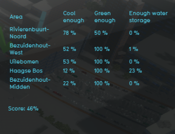
The indicator panel (see the image on the right) shows in a table per neighborhood:
- the neighborhood name
- If the neighborhood is cool enough
- If the neighborhood is green enough
- If there is enough water storage in the neighborhood
Calculation
The calculation on if a neighborhood is cool enough is can be read here section. If a neighborhood has enough green is calculated by comparing the amount of m² green (grassland, open land and dunes) to the amount of m² total land. To reach a score of 100% on green enough, an area needs to consist of 20% green. This percentage can be changed in the excel file. If the neighborhood has enough water storage is calculated by comparing the amount of m² terrain with water storage to the amount of m² total land. To reach a score of 100% of enough water storage, an area needs to consist of 30% water. This percentage can be changed in the excel file.
Score
The score is represented a progress bar, with a scale from 0 to 100%. This is the average of the progress on how cool, how green the area is and how much water storage there is in the area. Determine if you want to calculate the absolute or relative score. The higher the score, the more sustainable the neighborhoods in the project are.
Additional configurations
For this indicator to function, only the heat stress overlay has to be added to the project, see below for the steps.
Add the Heat stress overlay
When the indicator is added to the project, an error message can be given. This is due to the missing Heat stress overlay in the project. Read below on how to add this overlay to the project.
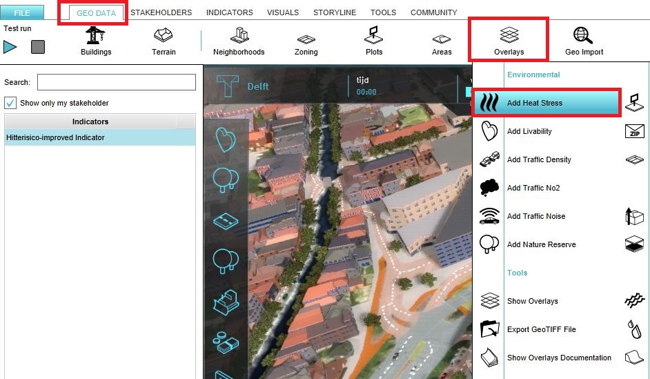
- Select in the editor 'Geo Data' from the ribbon
- Select 'Overlays' from the ribbon bar
- Select the Heat stress overlay from the drop down menu
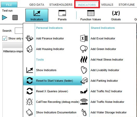
- Click on the tab Indicators and the button Indicators and choose for Reset to Start values (faster) to update your project.


