How to calculate the daily average wind speed: Difference between revisions
Jump to navigation
Jump to search
No edit summary |
No edit summary |
||
| Line 4: | Line 4: | ||
[[File:Tutorial_daily_wind_speed_table_(Heat_Overlay).png]] | [[File:Tutorial_daily_wind_speed_table_(Heat_Overlay).png]] | ||
{{article end | |||
The wind speed ([[ | |notes= | ||
* The wind speed ([[KNMI weather data#Hourly_wind_speed|hourly]], and [[KNMI weather data#Daily_average_wind_speed|daily average]]) can also be based on an other data source; ''Potentiele wind (UP)'': http://projects.knmi.nl/klimatologie/onderzoeksgegevens/potentiele_wind-sigma/. These values are often a few 0.1 m/s higher than the values from the historical KNMI weather data table. | |||
|seealso= | |||
* [[KNMI weather data]] | |||
}} | |||
{{Heat Module buttons}} | |||
{{ | |||
Revision as of 15:34, 7 November 2022
Daily average wind speed
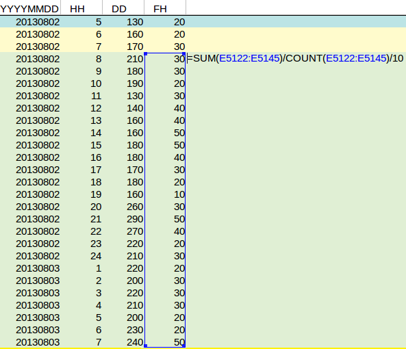
The daily average wind speed has to be measured from 8 UTC current day to 7 UTC the next day, according to the DPRA Heat stress report. The wind speed is also measured in 0.1 meters, so the values has to be divided by 10 to get to a value in m/s.
Notes
- The wind speed (hourly, and daily average) can also be based on an other data source; Potentiele wind (UP): http://projects.knmi.nl/klimatologie/onderzoeksgegevens/potentiele_wind-sigma/. These values are often a few 0.1 m/s higher than the values from the historical KNMI weather data table.
See also


