Rasterization (Distance Overlay): Difference between revisions
Jump to navigation
Jump to search
(Created page with "{{Overlay property|<onlyinclude> {{Overlay property|type=row|group=Distance Overlay |property=Rasterization |description=The rasterization method of a Distance Overlay |defaultvalue=n/a |icon=distancewizard_icon_rasterization.png }}</onlyinclude>}} Possible values: # FIRST: Attribute: First layer # MIN: Attribute: Min value # MAX: Attribute: Max value # SINGLE LAYER: Attribute: Specific layer # GRID: Grid: Input Overlay {{article end |seealso= * Attribute model (...") |
No edit summary |
||
| (7 intermediate revisions by the same user not shown) | |||
| Line 1: | Line 1: | ||
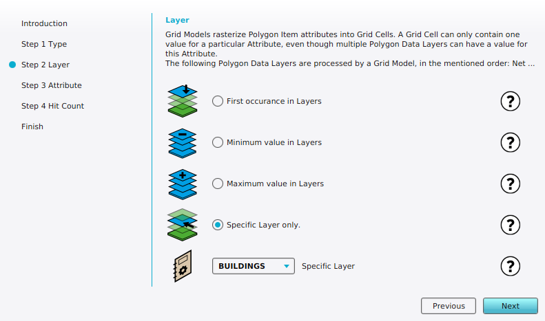
[[File:rasterization_overlay_wizard_layer_step.png|right|thumb|Layer step in the Distance Overlay Wizard when you can select the method of rasterization.]] | |||
{{Overlay property|<onlyinclude> | {{Overlay property|<onlyinclude> | ||
{{Overlay property|type=row|group=Distance Overlay | {{Overlay property|type=row|group=Distance Overlay | ||
|property=Rasterization | |property=Rasterization | ||
|description=The rasterization method of a [[Distance Overlay]] | |description=The rasterization method of a [[Distance Overlay]] | ||
|defaultvalue= | |defaultvalue='''First''' | ||
|icon=distancewizard_icon_rasterization.png | |icon=distancewizard_icon_rasterization.png | ||
}}</onlyinclude>}} | }}</onlyinclude>}} | ||
Possible values: | Possible values: | ||
# FIRST: Attribute: First layer | # '''FIRST''': Attribute: First layer | ||
# MIN: Attribute: Min value | # '''MIN''': Attribute: Min value | ||
# MAX: Attribute: Max value | # '''MAX''': Attribute: Max value | ||
# SINGLE LAYER: Attribute: Specific layer | # '''SINGLE LAYER''': Attribute: [[Maplink (Distance Overlay)|Specific layer]] | ||
# GRID: Grid: Input Overlay | # '''GRID''': Grid: Input Overlay | ||
{{article end | {{article end | ||
| Line 18: | Line 20: | ||
* [[Attribute model (Distance Overlay)]] | * [[Attribute model (Distance Overlay)]] | ||
* [[Grid model (Distance Overlay)]] | * [[Grid model (Distance Overlay)]] | ||
* [[Maplink (Distance Overlay)]] | |||
}} | }} | ||
{{DistanceOverlay nav}} | |||
Latest revision as of 15:37, 2 February 2024
| Icon | Property | Description | Default value |
|---|---|---|---|
| |
Rasterization | The rasterization method of a Distance Overlay | First |
Possible values:
- FIRST: Attribute: First layer
- MIN: Attribute: Min value
- MAX: Attribute: Max value
- SINGLE LAYER: Attribute: Specific layer
- GRID: Grid: Input Overlay
See also
