Water Module Basics: Difference between revisions
No edit summary |
mNo edit summary |
||
| (5 intermediate revisions by 2 users not shown) | |||
| Line 1: | Line 1: | ||
The [[Water Module]] in the {{software}} is an implementation of a 2D grid based shallow water model based on the 2D Saint Venant equations (see [[ | The [[Water Module]] in the {{software}} is an implementation of a 2D grid based shallow water model based on the 2D Saint Venant equations (see [[Surface model (Water Overlay)|surface model]]). The module is further enhanced with infiltration, evaporation, groundwater flow and hydraulic structures. This module simulates a water model for your project area, based on rainfall, breaches and existing open water.<br> | ||
<br> | |||
Take a look at the [[Testbed water module|testbed water module]] project, available in all domains, to see some of the components of the [[Water Module]] in a project. | |||
[[File:Rainfall overlay 05.PNG|600px|center]] | [[File:Rainfall overlay 05.PNG|600px|center]] | ||
To perform the calculations, the project area is divided into a [[Grid overlay|large grid of cells]]. Each cell has a specific quantity of water and specific hydrological parameters based on the data in the project. The total time which should be simulated is divided into discrete [[Timestep formula (Water Overlay)|timesteps]]. Per timestep, each cell communicates with its adjacent cells to exchange water, based on it's water level, surface height, current flow direction and other factors. Accuracy and reliability is obtained by dividing the project area and simulation time into sufficiently small cells and steps, at the cost of more computation time. | To perform the calculations, the project area is divided into a [[Grid overlay|large grid of cells]]. Each cell has a specific quantity of water and specific hydrological parameters based on the data in the project. The total time which should be simulated is divided into discrete [[Timestep formula (Water Overlay)|timesteps]]. Per timestep, each cell communicates with its adjacent cells to exchange water, based on it's water level, surface height, current flow direction and other factors. Accuracy and reliability is obtained by dividing the project area and simulation time into sufficiently small cells and steps, at the cost of more computation time. | ||
The Water Module enables users to implement a water model for their project which is accurate and delivers fast results. To ensure accuracy, the Water Module is repeatedly tested against multiple (internationally) acknowledged hydrological [[Water module benchmarks|benchmarks and tests]]. Fast results are achieved by executing the water calculations on High performance GPU servers. | The Water Module enables users to implement a water model for their project which is accurate and delivers fast results. To ensure accuracy, the Water Module is repeatedly tested against multiple (internationally) acknowledged hydrological [[Water module benchmarks|benchmarks and tests]]. Fast results are achieved by executing the water calculations on High performance GPU servers. | ||
| Line 13: | Line 12: | ||
[[File:Rainfall overlay 04.PNG|600px|center]] | [[File:Rainfall overlay 04.PNG|600px|center]] | ||
The {{software}} provides a large set of tools to import data, configure models and analyze and export results. These include: | ==More information== | ||
{{Water Module buttons}} | |||
<!--The {{software}} provides a large set of tools to import data, configure models and analyze and export results. These include: | |||
* Animated, multi timeframe overlays | * Animated, multi timeframe overlays | ||
* On-the-fly 1D and 2D-slice Measurement tools | * On-the-fly 1D and 2D-slice Measurement tools | ||
| Line 20: | Line 22: | ||
==Media== | ==Media== | ||
*[https://www.youtube.com/watch?v=S36yjjN_y0Q&t=28s Movie: Flooding module in the {{software}}] | * [https://www.youtube.com/watch?v=S36yjjN_y0Q&t=28s Movie: Flooding module in the {{software}}] | ||
*[https://www.youtube.com/watch?v=aGX_9JORdqw Movie: Dam Breach] | * [https://www.youtube.com/watch?v=aGX_9JORdqw Movie: Dam Breach] | ||
*[https://www.youtube.com/watch?v=CgBYRUwymoM Movie: Droogte/ Droughts (Dutch only)] | * [https://www.youtube.com/watch?v=CgBYRUwymoM Movie: Droogte/ Droughts (Dutch only)] | ||
*[https://www.youtube.com/watch?v=cuuft7_wbvU Movie: Waterkwaliteit/ Water Quality (Dutch only)] | * [https://www.youtube.com/watch?v=cuuft7_wbvU Movie: Waterkwaliteit/ Water Quality (Dutch only)] | ||
[[File: DamBreachMovieThumb1.png|thumb|400px|left|Still from Dam Breach movie]] | [[File: DamBreachMovieThumb1.png|thumb|400px|left|Still from Dam Breach movie]] | ||
{{clear}} | |||
==More information== | ==More information== | ||
{{Water Module buttons}} | {{Water Module buttons}} | ||
Latest revision as of 15:00, 14 June 2019
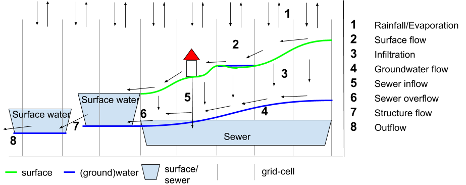
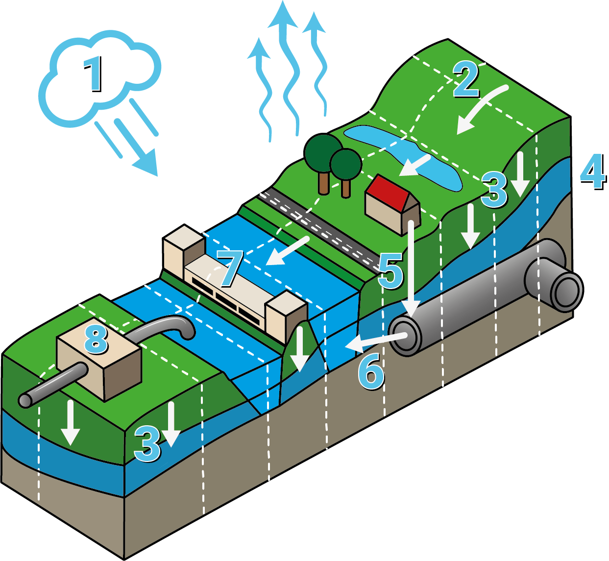
The Water Module in the Tygron Platform is an implementation of a 2D grid based shallow water model based on the 2D Saint Venant equations (see surface model). The module is further enhanced with infiltration, evaporation, groundwater flow and hydraulic structures. This module simulates a water model for your project area, based on rainfall, breaches and existing open water.
Take a look at the testbed water module project, available in all domains, to see some of the components of the Water Module in a project.

To perform the calculations, the project area is divided into a large grid of cells. Each cell has a specific quantity of water and specific hydrological parameters based on the data in the project. The total time which should be simulated is divided into discrete timesteps. Per timestep, each cell communicates with its adjacent cells to exchange water, based on it's water level, surface height, current flow direction and other factors. Accuracy and reliability is obtained by dividing the project area and simulation time into sufficiently small cells and steps, at the cost of more computation time.
The Water Module enables users to implement a water model for their project which is accurate and delivers fast results. To ensure accuracy, the Water Module is repeatedly tested against multiple (internationally) acknowledged hydrological benchmarks and tests. Fast results are achieved by executing the water calculations on High performance GPU servers.

More information


