Shoreline (Water Overlay): Difference between revisions
Jump to navigation
Jump to search
mNo edit summary |
No edit summary |
||
| (10 intermediate revisions by 3 users not shown) | |||
| Line 2: | Line 2: | ||
{{Overlay attributes|type=row|overlay=Water | {{Overlay attributes|type=row|overlay=Water | ||
|attribute=SHORELINE | |attribute=SHORELINE | ||
|unit= | |unit=Nominal value | ||
|range=0 to 2 | |||
|icon=Waterwizard_icon_shoreline.png | |||
|description=Whether to automatically fill cells near a water terrain when there is a mismatch between the extend of the water terrain and the DEM. | |description=Whether to automatically fill cells near a water terrain when there is a mismatch between the extend of the water terrain and the DEM. | ||
|defaultvalue=1 | |||
}}</onlyinclude>}} | }}</onlyinclude>}} | ||
When a Waterway polygon is not correctly positioned in relation to the DEM this can result in filling up the nearby land with water at the start of the simulation. This will result in a lower water level then is expected from the water | When a Waterway polygon is not correctly positioned in relation to the DEM this can result in filling up the nearby land with water at the start of the simulation. This will result in a lower water level then is expected from the water area value. To correct this, a "shoreline" is added at neighbouring cells. At the start of the simulation, these shoreline cells will also be filled with water up to the nearby water level to prevent the initial flush. | ||
{{nominal list|zeroindex=true | |||
|| '''None''' : No neighboring cells will be added to the shoreline. | |||
|| '''One cell''': Direct neighboring cells will be added to the shoreline (default). | |||
|| '''Two cells''': Direct and diagonal neighboring cells will be added to the shoreline. | |||
}} | |||
<gallery mode=nolines> | |||
File:Wateroverlay_shoreline.png|Water Overlay with shoreline active. | |||
File:Wateroverlay_without_shoreline.png|Water Overlay without shoreline active. | |||
File:Wateroverlay_difference_waterlevel.png|Difference in [[Surface last value result type (Water Overlay)|water level]]. | |||
</gallery> | |||
{{article end | {{article end | ||
|notes= | |notes= | ||
|howtos= | |howtos= | ||
* [[How to add and remove an Attribute]] | * [[How to add and remove an Attribute]] | ||
Latest revision as of 11:40, 30 October 2025
| Icon | Attribute | Unit | Range | Description | Default value |
|---|---|---|---|---|---|
| |
SHORELINE | Nominal value | 0 to 2 | Whether to automatically fill cells near a water terrain when there is a mismatch between the extend of the water terrain and the DEM. | 1 |
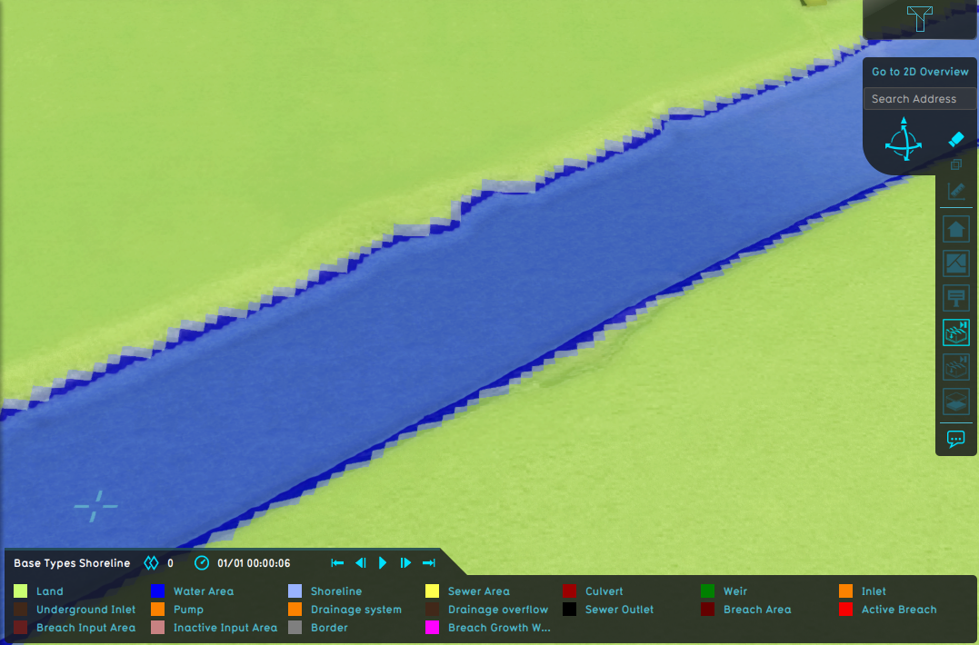
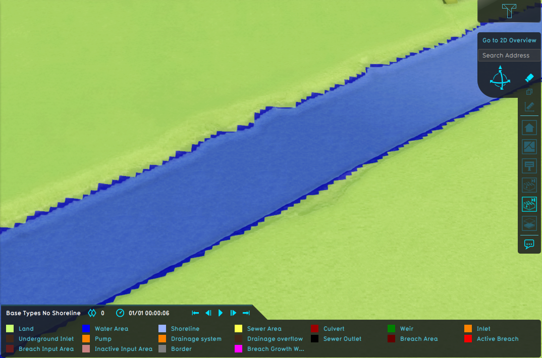
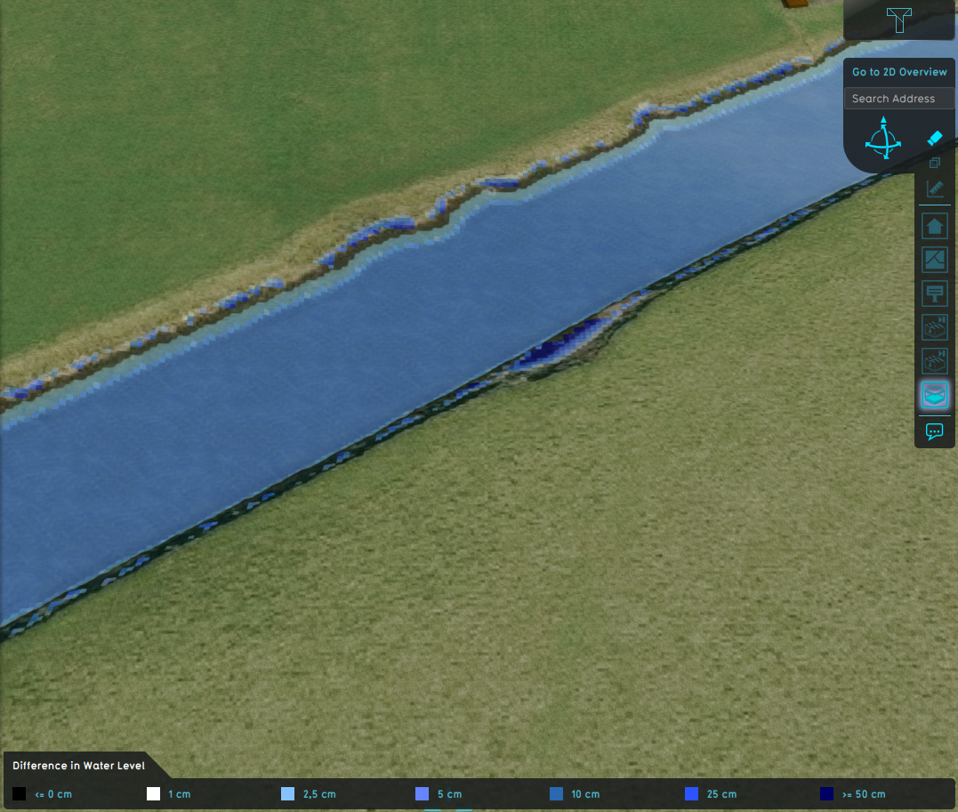
When a Waterway polygon is not correctly positioned in relation to the DEM this can result in filling up the nearby land with water at the start of the simulation. This will result in a lower water level then is expected from the water area value. To correct this, a "shoreline" is added at neighbouring cells. At the start of the simulation, these shoreline cells will also be filled with water up to the nearby water level to prevent the initial flush.
| 0. | None : No neighboring cells will be added to the shoreline. |
| 1. | One cell: Direct neighboring cells will be added to the shoreline (default). |
| 2. | Two cells: Direct and diagonal neighboring cells will be added to the shoreline. |
-
Water Overlay with shoreline active.
-
Water Overlay without shoreline active.
-
Difference in water level.


