Evaporation model (Water Overlay): Difference between revisions
(→Notes) |
|||
| (13 intermediate revisions by the same user not shown) | |||
| Line 1: | Line 1: | ||
Water can evaporate from the hydrological model over time. Multiple | Water can evaporate from the hydrological model, varying per grid cell and over time. Multiple types of evaporation are implemented; [[#Surface evaporation|surface]] and [[#Ground evaporation|ground evapotranspiration]]. | ||
Both forms of evaporation can be configured directly by setting the [[weather (Water Overlay)|weather]]'s [[Evaporation m (Water Overlay)|evaporation rate]]. The weather's evaporation rate is defined as a period during which a certain rate of evaporation will take place, similar to [[rain model (Water Overlay)|rainfall]]. Multiple periods | Both forms of evaporation can be configured directly by setting the [[weather (Water Overlay)|weather]]'s [[Evaporation m (Water Overlay)|evaporation rate]]. The weather's evaporation rate is defined as a period during which a certain rate of evaporation will take place, similar to [[rain model (Water Overlay)|rainfall]]. Multiple evaporation periods can be defined. | ||
The general evaporation amount per period is converted to an amount per second. | |||
In case less water is present at a particular grid cell, the amount of evaporation will be less than the maximum possible evaporation at the time in the simulation. The remainder will not be carried over to the next time step and will therefor always be discarded. | |||
The default setup for evaporation consists of a single period of evaporation. It is possible to configure an evaporation rate which [[How_to_load_in_dynamic_evaporation_rate_(Water_Overlay)|varies over time]]. More periods with varying amounts of evaporation (including an evaporation rate of zero) can be defined. | The default setup for evaporation consists of a single period of evaporation and an evaporation amount. It is possible to configure an evaporation rate which [[How_to_load_in_dynamic_evaporation_rate_(Water_Overlay)|varies over time]]. More periods with varying amounts of evaporation (including an evaporation rate of zero) can be defined. | ||
[[File:Evaporation_total.png]] | [[File:Evaporation_total.png]] | ||
==Surface evaporation== | ==Surface evaporation== | ||
Water situated on the [[Surface model (Water Overlay)|surface]] is conceptually able to evaporate. The amount is based on the [[weather (Water Overlay)|weather]]'s [[Evaporation m (Water Overlay)|evaporation rate]] and the overlay's [[Surface water evaporation factor | Water situated on the [[Surface model (Water Overlay)|surface]] is conceptually able to evaporate. The amount is based on the [[weather (Water Overlay)|weather]]'s [[Evaporation m (Water Overlay)|evaporation rate]] and the overlay's [[Surface water evaporation factor (Water Overlay)|SURFACE_WATER_EVAPORATION_FACTOR]]. The product of these two attributes results in the actual rate of evaporation. The water in each individual cell at the surface is then subject to the calculated rate of evaporation, according to the [[Surface evaporation formula (Water Overlay)|surface evaporation formula]]. | ||
==Ground evaporation== | ==Ground evaporation== | ||
| Line 22: | Line 23: | ||
In other words: if a building is present the building's properties are used, otherwise the terrain's properties are used. | In other words: if a building is present the building's properties are used, otherwise the terrain's properties are used. | ||
Conceptually, water can evaporate from the ground via | === Feddes factor === | ||
Conceptually, water can evaporate from the ground via crop, tree and plant foliage. Their roots can draw water from the unsaturated and saturated zones in the ground, when these reach deep enough and the [[Water evaporation factor (Water Overlay)|evaporation factor]] is non-zero. Water is drawn from the ground and evaporated into the air, effectively removing it from the hydrological model. | |||
Water for evaporation can only be drawn from sections of the ground which are within reach of the roots, as defined by the root depth. Using the multiple root depth values, it is also possible to define a threshold at which the roots are unable, or less able, to extract ground water, due to oxygen stress. It such case up to 4 root depth values have to be provided, from deepest to less deep. | Water for evaporation can only be drawn from sections of the ground which are within reach of the roots, as defined by the root depth. Using the multiple root depth values, it is also possible to define a threshold at which the roots are unable, or less able, to extract ground water, due to oxygen stress. It such case up to 4 root depth values have to be provided, from deepest to less deep. | ||
[[File:Feddes_trapezium.jpg]] | [[File:Feddes_trapezium.jpg|500px]] | ||
The ground evaporation can be configured directly by changing the terrain type's [[terrain water evaporation factor (Water Overlay)|WATER_EVAPORATION_FACTOR]] and building 's [[Water evaporation factor (Water Overlay)|WATER_EVAPORATION_FACTOR]]. If these attributes are set to 0, no ground evaporation will take place. | === Seasonal factor === | ||
[[File:Seasonal_evap_grass.jpg|thumb|right|Varying [[Water evaporation factor (Water Overlay)|evaporation factor]] of grass, depending on the [[Season formula (Water Overlay)|time of year]].]] | |||
The ground evaporation can be configured directly by changing the terrain type's [[terrain water evaporation factor (Water Overlay)|WATER_EVAPORATION_FACTOR]] and building 's [[Water evaporation factor (Water Overlay)|WATER_EVAPORATION_FACTOR]]. If these attributes are set to 0, no ground evaporation will take place. This attribute can also be set as 4 distinct values, one for each [[Season formula (Water Overlay)|growth season]]. This allows for more evaporation during a crops growth season and less during the winter. | |||
=== Varying evaporation rate=== | |||
Similar to the [[#Surface evaporation|surface evaporation]], the rate of ground evaporation is also determined by the [[Weather (Water Overlay)|weather definition]]'s [[Evaporation m (Water Overlay)|evaporation rate]]. Multiplying the weather's evaporation rate and the evaporation factor of the building or terrain (as applicable) gives the actual evaporation rate for the ground. | Similar to the [[#Surface evaporation|surface evaporation]], the rate of ground evaporation is also determined by the [[Weather (Water Overlay)|weather definition]]'s [[Evaporation m (Water Overlay)|evaporation rate]]. Multiplying the weather's evaporation rate and the evaporation factor of the building or terrain (as applicable) gives the actual evaporation rate for the ground. | ||
Latest revision as of 14:57, 5 March 2024
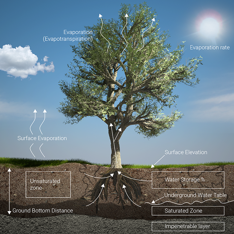
Water can evaporate from the hydrological model, varying per grid cell and over time. Multiple types of evaporation are implemented; surface and ground evapotranspiration.
Both forms of evaporation can be configured directly by setting the weather's evaporation rate. The weather's evaporation rate is defined as a period during which a certain rate of evaporation will take place, similar to rainfall. Multiple evaporation periods can be defined. The general evaporation amount per period is converted to an amount per second.
In case less water is present at a particular grid cell, the amount of evaporation will be less than the maximum possible evaporation at the time in the simulation. The remainder will not be carried over to the next time step and will therefor always be discarded.
The default setup for evaporation consists of a single period of evaporation and an evaporation amount. It is possible to configure an evaporation rate which varies over time. More periods with varying amounts of evaporation (including an evaporation rate of zero) can be defined.
Surface evaporation
Water situated on the surface is conceptually able to evaporate. The amount is based on the weather's evaporation rate and the overlay's SURFACE_WATER_EVAPORATION_FACTOR. The product of these two attributes results in the actual rate of evaporation. The water in each individual cell at the surface is then subject to the calculated rate of evaporation, according to the surface evaporation formula.
Ground evaporation
Water can evaporate from the ground if the cell's surface meets either of the following criteria:
- A building on the surface
- The building has a non-zero WATER_EVAPORATION_FACTOR.
- The building has a non-zero root depths.
- No building on the surface
- The surface terrain type has a non-zero WATER_EVAPORATION_FACTOR.
- The surface terrain type has a non-zero root depths.
In other words: if a building is present the building's properties are used, otherwise the terrain's properties are used.
Feddes factor
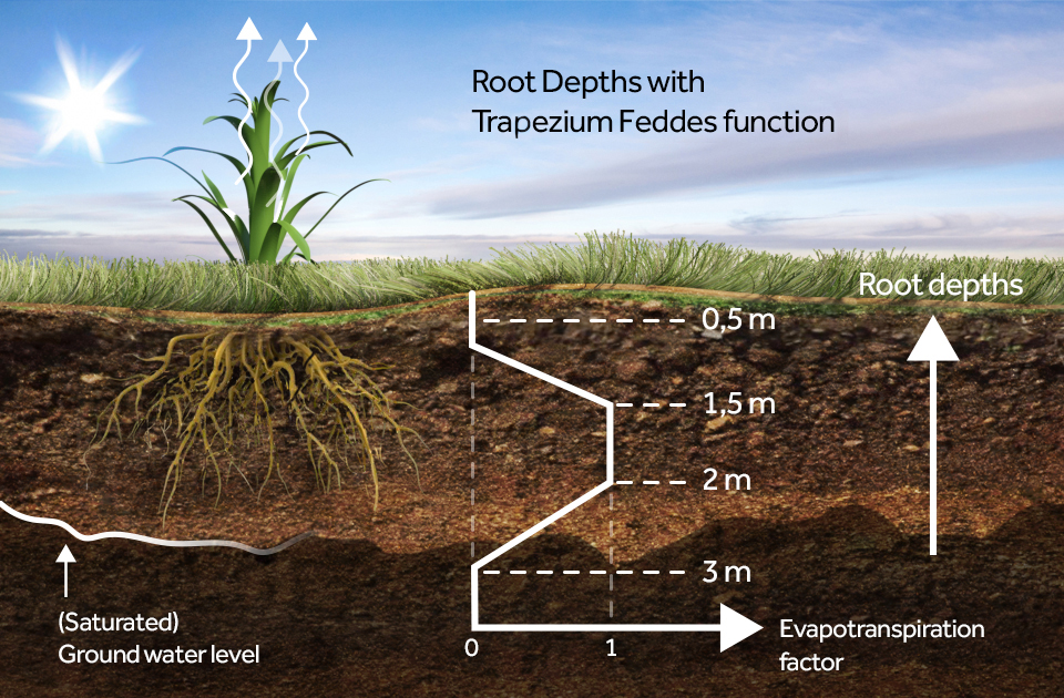
Conceptually, water can evaporate from the ground via crop, tree and plant foliage. Their roots can draw water from the unsaturated and saturated zones in the ground, when these reach deep enough and the evaporation factor is non-zero. Water is drawn from the ground and evaporated into the air, effectively removing it from the hydrological model. Water for evaporation can only be drawn from sections of the ground which are within reach of the roots, as defined by the root depth. Using the multiple root depth values, it is also possible to define a threshold at which the roots are unable, or less able, to extract ground water, due to oxygen stress. It such case up to 4 root depth values have to be provided, from deepest to less deep.
Seasonal factor
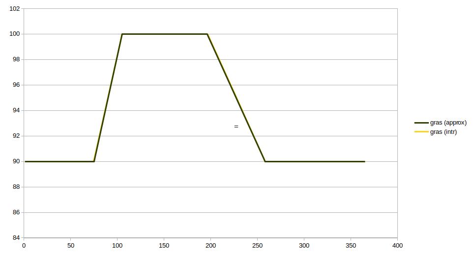
The ground evaporation can be configured directly by changing the terrain type's WATER_EVAPORATION_FACTOR and building 's WATER_EVAPORATION_FACTOR. If these attributes are set to 0, no ground evaporation will take place. This attribute can also be set as 4 distinct values, one for each growth season. This allows for more evaporation during a crops growth season and less during the winter.
Varying evaporation rate
Similar to the surface evaporation, the rate of ground evaporation is also determined by the weather definition's evaporation rate. Multiplying the weather's evaporation rate and the evaporation factor of the building or terrain (as applicable) gives the actual evaporation rate for the ground.
Ground evaporation first draws water from the unsaturated region and then from the saturated region. If, according to the calculated evaporation rate, a sufficient amount of water can evaporate from the unsaturated zone, no water will evaporate from the saturated zone. Otherwise, all water in the unsaturated zone which is in reach of the roots of the building or terrain (as applicable) is evaporated, and the remainder of the amount of water which should evaporate according to the evaporation rate is evaporated from the saturated zone. The sum of evaporation in the unsaturated zone and the saturated zone will never exceed the calculated evaporation rate.
Example for dynamic evaporation
See the table below for an example of dynamic evaporation:
| Time key (minutes) | Evaporation rate (mm/d) |
|---|---|
| 35 | 1,5 |
| 42 | 1,9 |
| 120 | 0,5 |
For the sake of simplicity, we will assume a surface water evaporation factor of 1. We will also assume that there is sufficient water to evaporate.
This format can be interpreted as follows:
- The first period is starts at t=0 minutes and ends at t=35 minutes. In this first period, water will evaporate at a rate of 1,5 mm per day. Uniformly this gives 1,5 / (24 * 60 * 60) = 0.000017 mm per second.
- The second period starts at t=35 minutes and ends at t=42 minutes. In this period, water will evaporate at a rate of 19 mm per day. Uniformly this is 1,9 / (24 * 60 * 60) = 0.000022 mm per second.
- The last period starts at t=42 minutes and ends at t=120 minutes. In this period, water will evaporate at a rate of 5 mm per day. Uniformly this is 0,5 / (24 * 60 * 60) = 0,000006 mm per second.
In total it can be expected that 1,5 * ( (35-0) / (24*60) ) + 1,9 * ( (42-35) / (24*60) ) + 0,5 * ( (120-42) / (24*60) ) = 0.036 + 0.009 + 0.027 = 0,0728 mm of water will have evaporated in a total simulation time of 120 minutes.
If, during any timestep, the amount of water present is less than what is calculated to evaporate, the water present will evaporate, but because there was not enough water to evaporate, the actual total amount of evaporation will be less than the amount that was calculated to potentially evaporate.
Notes
- The configuration wizard is the easiest way to adjust evaporation and rainfall.
- If the weather's evaporation rate is set to 0, no evaporation will take place in any form.
- A period without evaporation can be simulated by setting the evaporation rate for a period to zero.
- An evaporation rate of zero is allowed, but a negative evaporation rate is not. Negative evaporation rate is treated as zero.
- Ground evaporation will only take place when the ground model is active.
- The evaporation table is stored as the attribute array with the name EVAPORATION_M. This attribute is part of the weather definition associated with the Water Overlay.
- The underlying attribute array defines time in seconds.
- The next time key should always be larger than the previous time key.
- If the next time key for the evaporation rate is smaller than the previous time key for rainfall, the previous rate of evaporation is continued until the end of the simulation.


