How to select specific input data for AI Inference
[Work In Progress]
It is possible to mask the image layer of a satellite input in a Combo Overlay. This way you can specifically in- or exclude certain areas from the Inference Overlay. Below you will find two examples, which require that you already have a regular inference overlay set up.
Exclude open water areas from an Inference Overlay
How to exclude open water from an Inference Overlay:
- Add an Average Overlay, we will use this to assign water areas.
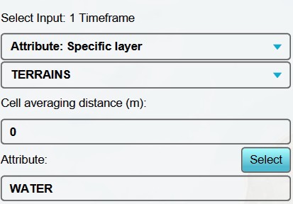
- With this overlay selected, set the input options to "Attribute: Sepeciffic Layer" and "Terrains".
- Because we want a sharp distinction between water and land, we set the cell averaging distance to 0 meters.
- As attribute to look for, we select "WATER".
- Select finally "Update Now", and you have created an overlay that displays all open water areas.
- Now add a Combo Overlay.
- Select the Original Satellite overlay as input for Grid A.
- Select the Avg Water Terrains overlay as input for Grid B.
- Enter the following formula: "IF(GT(B, 0), NO_DATA, A)". This formula checks wether a point is in a water area. If so, return no data, else return the satelite image.
- Select again "Update Now".
- Now use this new combo overlay with a fitered satelite image as input for your inference overlay, and update. You have now excluded open water areas from your inference overlay.
Notes
- The detected foliage overlay can be used to import as trees or foliage areas into your project.
