Shade calculation model (Heat Overlay): Difference between revisions
No edit summary |
No edit summary |
||
| (13 intermediate revisions by 3 users not shown) | |||
| Line 1: | Line 1: | ||
Shades are an important factor in the [[Heat Overlay]]. Whether a cell is shaded or not determines which PET function is used, PET<sub>sun</sub> or PET<sub>shade, night</sub>. In the model described by the {{Template:Heat DPRA Report}}, cells can be shaded by buildings, terrain and foliage. | |||
The shade is dependent on the location of the sun. This in turn is dependent on the [[ | The shade is dependent on the location of the sun. This in turn is dependent on the [[Dates (Heat Overlay)|date and the time of day]] and the world location of the project. | ||
Since each timeframe result of a [[ | Since each timeframe result of a [[Heat Overlay]] is related to a particular date and time of day, each time frame will have a related [[Sun altitude (Heat Overlay)|sun altitude]] and [[Sun azimuth (Heat Overlay)|sun azimuth angle]]. These angles are calculated automatically based on the world location of your project and the [[Dates (Heat Overlay)|date]] of the timeframe. | ||
Once the sun angles and the building, terrain and foliage height are known, the | Once the sun angles and the building, terrain and foliage height are known, whether the cell is shaded or not is computed as follows for each cell: | ||
# Travel away from the cell in the direction of the sun azimuth angle. | # Travel away from the cell in the direction of the sun azimuth angle. | ||
# For each | # For each cell traversed this way, calculate the height of the sun ray based on the altitude angle. | ||
# Compare the sun ray altitude with the maximum height (terrain, building and foliage) at the cell. | # Compare the sun ray altitude with the maximum height (terrain, building and foliage) at the traversed cell. | ||
## | ## If the surface height in the traversed cell higher, the cell is shaded and we can stop. | ||
## | ## If the sun ray altitude in the traversed cell is higher, the calculation is performed again for the next traversed cell. | ||
## If all cells are traversed and the computation didn't stop in any cell, the cell can be reached by direct sunlight and the cell is not shaded. | |||
<gallery mode="nolines"> | |||
File:shaded Heat Overlay.png|300px|Rays to the sky are blocked by a tall construction, so the cell is considered to be in the shade. | |||
File:unshaded Heat Overlay.png|300px|Rays to the sky are uninterrupted, so the cell is in direct sunlight. | |||
</gallery> | |||
[[File: | [[File:Shade top_down.png|400px]] | ||
{{ | {{article end | ||
|notes= | |||
* Shade calculations are based on the heights of [[Building]]s starting from the ground. When a [[Building]]s references to a [[Custom Geometry]], for any grid cell a building is considered solid all the way from the ground up to the highest part of the [[Custom Geometry]] within that grid cell. This allows for detailed roofs, shadows, and tapering shapes, but will not include holes within the height of the building, such as spaces under balconies. The exact interpreted heights can be inspected via a [[Digital Surface Model Overlay]]. | |||
* This model uses a maximum ray testing range, which can be configured using the [[Max shadow distance (Heat Overlay)|MAX_SHADOW_DISTANCE]]. This setting can be configured with a values between 100 m and 1000 m. This also means that calculated shadows cannot potentially be larger than the configured distance. The maximum shadow distance has no effect on the orientation of the shade. | |||
|seealso= | |||
* [[Shade result type (Heat Overlay)]] | |||
}} | |||
{{HeatOverlay formula nav}} | |||
Latest revision as of 15:09, 23 January 2024
Shades are an important factor in the Heat Overlay. Whether a cell is shaded or not determines which PET function is used, PETsun or PETshade, night. In the model described by the DPRA Heat stress report, cells can be shaded by buildings, terrain and foliage.
The shade is dependent on the location of the sun. This in turn is dependent on the date and the time of day and the world location of the project.
Since each timeframe result of a Heat Overlay is related to a particular date and time of day, each time frame will have a related sun altitude and sun azimuth angle. These angles are calculated automatically based on the world location of your project and the date of the timeframe.
Once the sun angles and the building, terrain and foliage height are known, whether the cell is shaded or not is computed as follows for each cell:
- Travel away from the cell in the direction of the sun azimuth angle.
- For each cell traversed this way, calculate the height of the sun ray based on the altitude angle.
- Compare the sun ray altitude with the maximum height (terrain, building and foliage) at the traversed cell.
- If the surface height in the traversed cell higher, the cell is shaded and we can stop.
- If the sun ray altitude in the traversed cell is higher, the calculation is performed again for the next traversed cell.
- If all cells are traversed and the computation didn't stop in any cell, the cell can be reached by direct sunlight and the cell is not shaded.
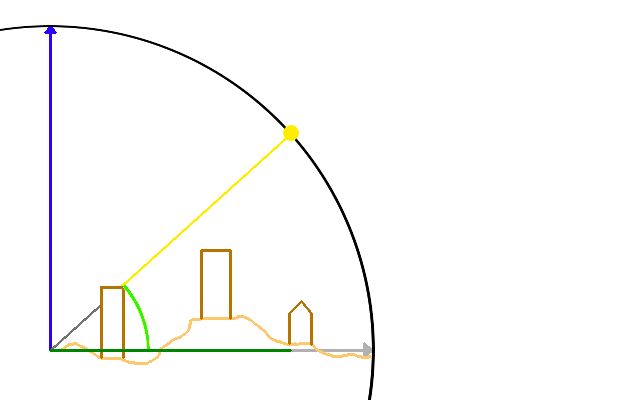
Rays to the sky are blocked by a tall construction, so the cell is considered to be in the shade.
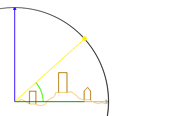
Rays to the sky are uninterrupted, so the cell is in direct sunlight.


Notes
- Shade calculations are based on the heights of Buildings starting from the ground. When a Buildings references to a Custom Geometry, for any grid cell a building is considered solid all the way from the ground up to the highest part of the Custom Geometry within that grid cell. This allows for detailed roofs, shadows, and tapering shapes, but will not include holes within the height of the building, such as spaces under balconies. The exact interpreted heights can be inspected via a Digital Surface Model Overlay.
- This model uses a maximum ray testing range, which can be configured using the MAX_SHADOW_DISTANCE. This setting can be configured with a values between 100 m and 1000 m. This also means that calculated shadows cannot potentially be larger than the configured distance. The maximum shadow distance has no effect on the orientation of the shade.
See also


