How to correct multiple buildings on the same location
When working with the Water Overlay, only one hydraulic structure per grid cell may exist. However, your data may contain situations where multiple such buildings (or rather the endpoints thereof) are in the same location. When object correction is configured for the water overlay, the water model rasterizer will try to find an alternative location for the building around the original location. However, in case the model cannot find an alternative location for the building, it will be non-functional and marked as invalid. Buildings which have invalid placements can be inspected after the overlay has been calculated by opening the water overlay wizard and inspecting the error feedback for the specific steps.
In case buildings are marked as invalid, it is recommended to make the corrections using an external GIS tool before loading in the data.
Situations
When these issues arise, this may be due to different causes. For all use-cases, it is important to preserve the intended topology. For this reason, the proper method to resolve the issue is dependent on the cause.
Multiple parallel Buildings of the same type
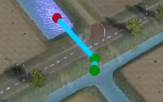
There may be multiple buildings of the same type, placed in parallel. For example, the multiple individual pumps of a pumping station may be registered in the data as individual buildings, or there are multiple culvert tubes parallel to one another connecting two waterways.
How to correct:
In this situation, it is recommended to merge the Buildings into a single Building. Replace the separate Buildings with a single Building, with its Attributes configured such that it has the same capacity for flow-through as the individual Buildings combined.
-
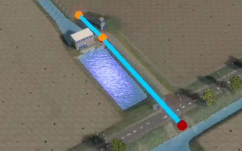
 Two culverts parallel to each other, too close to each other.
 -
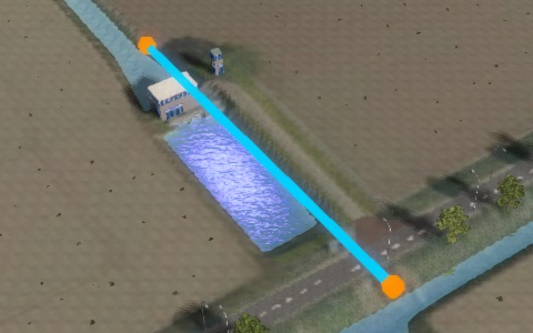
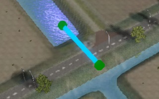
 A single culvert with the merged properties of the original culverts.


Inlet or Sewer Overflow attached to other buildings
There may be a composite building, such as a Sewer Overflow or an Inlet or Outlet directly connected to a Culvert making the water flow entirely to a different location. This means that although geographically the Inlet is in a specific location, topologically its effect is in a different location.
How to correct:
In this situation, it is recommended to merge the Buildings into a single on in a single location. Move the point-based Building to the other endpoint of the line-based Building, and remove the line-based Building itself. If necessary, tweak the remaining Building's Attributes to include the restrictive properties of the now removed line-based Building. I.e., if the removed Building would only allow a small amount of water to flow through, the remaining Building should also only allow a small amount of water to flow through.
-
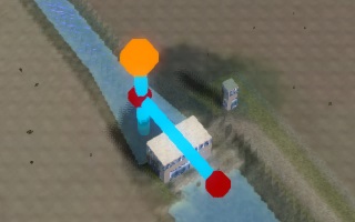 Two buildings connected together.
 -
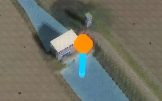 Simplified situation, topologically identical.


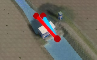
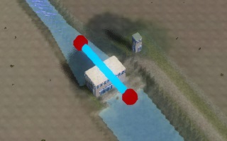
Pump attached in sequence to other buildings
There may be a composite building which includes a pump and another line-based structure, connected together so that topologically water is moved directly from one endpoint of one Building to the other endpoint of the other structure. The net effect is that it's those two far endpoints that are topologically connected, and the Pump dictates the flow direction of the water.
How to correct:
In this situation, it is recommended to remove the Building that isn't a Pump, and to move the endpoint of the Pump that was connected to the other structure to the location where the other Building's other endpoint was. If necessary, tweak the Pump's Attributes to include the restrictive properties of the now removed Building. I.e., if the removed Building would only allow a small amount of water to flow through, the Pump should only have a maximum capacity to pump through a small amount of water (taking into account whether the pump could force water through under higher pressure).
-
 A pump connected to a culvert.
 -
 A single pump, topologically identical.


Multiple buildings of the same type in sequence
There may be multiple Buildings of the same type, placed in sequence. For example, a culvert may turn a corner underground (ie. lay in an L-shape), which may be represented in data as 2 separate Culverts for each straight segment.
How to correct:
In this situation, it is recommended to combine the two Buildings into a single Building, the endpoints of which are the endpoints on the far sides of the original structures. The Attributes of the resulting Building should be the most restrictive of the Attributes of the original structures.
-
 A pump connected to a culvert.
 -
 A single pump, topologically identical.


Culvert attached to weir
There may be a composite building which includes a Culvert and a Weir, such as a culvert of which one side is partially blocked off by a weir, or a weir inside a culvert. The net effect is that both Buildings can have some limiting effect on the flow-through.
How to correct:
In this situation, first determine which Building is the most important limiting factor on flow-through. If the expectation is that there will not be too much water in the system, the Weir is most likely to be the most limiting factor. Remove the Culvert, and move the endpoints of the Weir to match where the Culvert was. If the expectation is that the amount of water may exceed the capacity of the Culvert, the Culvert is most likely to be the limiting factor. Remove the Weir. After removing either the Weir or the Culvert, consider whether the Attributes of the remaining Building should be tweaked. For example, if the Weir is removed and its threshold is higher than the threshold of the Culvert, the threshold of the Culvert should be changed to match the Weir's threshold.
-
 A culvert with a weir on one end.
 -
 The entire combined building replaced with a single weir.


Unconnected buildings near each other
The endpoints of two buildings might just happen to be close by each other, but not necessarily connected directly to one another. This means that topologically the water can flow out of one building, and separately can flow into the other building, or just flow or remain on the terrain. However, by being too close to each other, one may be non-functional. When object correction is not active for the water overlay, one of the building has be corrected manually.
How to correct:
In this situation, both Buildings should be preserved, otherwise the topology is not preserved. Move the endpoints of the structures away from one another. If you already know the desired grid cell size of the Project with which the data will be used, a good rule of thumb is that each endpoint should be at least 1.5 times that size away from any other endpoint.
-
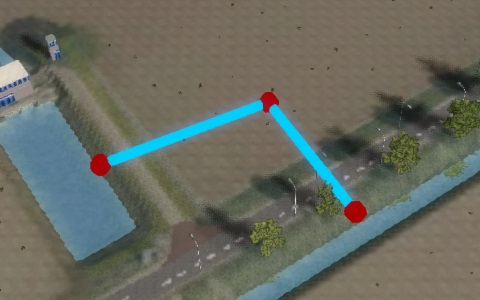
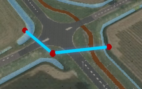 Two buildings close to one another.
 -
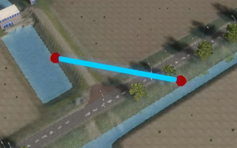
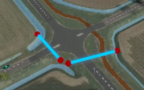 The endpoints of the buildings moved apart.


Notes
- Only the endpoints for line-based Buildings and centers for point-based Buildings "count". The rest of the polygon is disregarded. This means it is allowed for wider polygons to overlap, or for line-based structures to cross one another.
- The definition for "being in the same location" is strictly "in the same grid cell". This means that these issues may arise more easily as the grid cell size increases, and may be more easily avoided as the grid cell size decreases.