Water Overlay ground model cheatsheet: Difference between revisions
Jump to navigation
Jump to search
mNo edit summary Tag: Manual revert |
No edit summary |
||
| Line 72: | Line 72: | ||
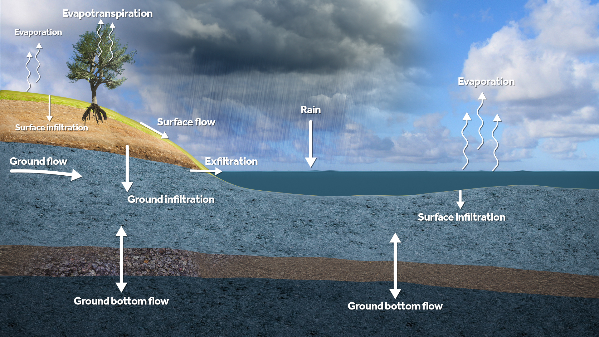
|image=Water_module_flows.jpeg | |image=Water_module_flows.jpeg | ||
|table= | |table= | ||
}} | |||
{{cheatsheet-block | |||
|title=Output Overlays | |||
|type=results | |||
|datatype=Water Overlay Result Types | |||
|datatypelink=Result type (Water Overlay) | |||
|text= | |||
|image= | |||
|table= | |||
{{{!}} | |||
! Mode !! Description | |||
{{!}}- | |||
{{!}} GROUND_WATERTABLE {{!}}{{!}} Groundwater level, in meters relative to reference datum. | |||
{{!}}- | |||
{{!}} GROUND_WATERTABLE_WITH_SURFACE {{!}}{{!}} Combines GROUND_WATERTABLE with water on the surface when groundwater level is near the surface. | |||
{{!}}- | |||
{{!}} GROUND_FLOW {{!}}{{!}} Horizontal flow of groundwater. | |||
{{!}}- | |||
{{!}} GROUND_BOTTOM_FLOW {{!}}{{!}} Groundwater flow via the bottom of the saturated zone. | |||
{{!}}- | |||
{{!}} GROUND_LAST_STORAGE {{!}}{{!}} Current amount of water in the unsaturated and saturated zones combined. | |||
{{!}}- | |||
{{!}} GROUND_MAX_STORAGE {{!}}{{!}} Highest recorded amound of water in the unsaturated and saturated zones combined. | |||
{{!}}- | |||
{{!}} GROUND_LAST_UNSATURATED_STORAGE {{!}}{{!}} Amount of water in the unsaturated zone. | |||
{{!}}- | |||
{{!}} GROUND_LAST_UNSATURATED_FRACTION {{!}}{{!}} Fraction of total amount of storage available in unsaturated zone which is actually filled with water. | |||
{{!}}- | |||
{{!}} EVAPORATED {{!}}{{!}} Total evaporation recorded, including evapotranspiration through vegetation. | |||
{{!}}} | |||
}} | }} | ||
}} | }} | ||
Revision as of 11:20, 14 March 2025
Core principles
In the 2-dimensional grid model of the Tygron Platform, water infiltrates from the surface, infiltrates through the unsaturated zone and is partially stored, after which it reaches the saturated zone. Here, horizontal flow occurs, depending on hydraulic gradients and permeability, and everything is simulated in a time-dependant context. There is no vertical (and no radial) flow in the saturated zone.
Unsaturated zone Terrain Type: Attributes
| Parameter | Unit | Description |
|---|---|---|
| UNSATURATED_FRACTION | fraction | Initial value saturation E.g. 0.5 means pores are 50% filled with water. |
| WATER_STORAGE_PERCENTAGE | m³/m³ | Effective porosity. Determines water storage capacity. |
| GROUND_INFILTRATION_MD | m/day | Maximum infiltration speed in this type of terrain. |
Saturated zone Terrain Type: Attributes
| Parameter | Unit | Description |
|---|---|---|
| HYDRAULIC_CONDUCTIVITY | m/day | Horizontal conductivity. |
| HYDRAULIC_CONDUCTIVITY_WITH_THICKNESS_MD | m²/day | Horizontal conductivity corrected for layer thickness. |
Simulation modes Water Overlay Wizard
| Mode | Description |
|---|---|
| None | No groundwater processes are simulated. Surface is impermeable. |
| Infiltration only | Only infiltration into the unsaturated zone is simulated. Storage is defined by MAX_INFILTRATION_M. |
| Complete | Complete simulation of infiltration, flow, and evaporation. |
Output Overlays Water Overlay Result Types
| Mode | Description |
|---|---|
| GROUND_WATERTABLE | Groundwater level, in meters relative to reference datum. |
| GROUND_WATERTABLE_WITH_SURFACE | Combines GROUND_WATERTABLE with water on the surface when groundwater level is near the surface. |
| GROUND_FLOW | Horizontal flow of groundwater. |
| GROUND_BOTTOM_FLOW | Groundwater flow via the bottom of the saturated zone. |
| GROUND_LAST_STORAGE | Current amount of water in the unsaturated and saturated zones combined. |
| GROUND_MAX_STORAGE | Highest recorded amound of water in the unsaturated and saturated zones combined. |
| GROUND_LAST_UNSATURATED_STORAGE | Amount of water in the unsaturated zone. |
| GROUND_LAST_UNSATURATED_FRACTION | Fraction of total amount of storage available in unsaturated zone which is actually filled with water. |
| EVAPORATED | Total evaporation recorded, including evapotranspiration through vegetation. |
