Bridge elevation (Water Overlay): Difference between revisions
Jump to navigation
Jump to search
No edit summary |
No edit summary |
||
| Line 10: | Line 10: | ||
}}</onlyinclude>}} | }}</onlyinclude>}} | ||
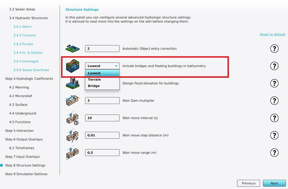
The water model uses an elevation model for the surface flow calculations. This setting defines how to include bridges in this elevation model: | |||
{{nominal list|zeroindex=true | {{nominal list|zeroindex=true | ||
||'''Lowest''': | ||'''Lowest''': The lowest elevation point from the terrain elevation (DTM) below bridge is used, when the terrain is '''[[Water (Terrain Attribute)|water]]'''. Otherwise the behavior is similar to '''Terrain'''. | ||
||'''Terrain''': | ||'''Terrain''': Under bridges, the terrain elevation (DTM) is used, otherwise the [[#Notes|limited]] surface elevation (DSM) is used. Water can flow under the bridge according to the terrain elevation. | ||
||'''Bridge''' : Use bridge deck as elevation. Bridges and [[Align elevation (Function Value)|floating]] | ||'''Bridge''' : Use bridge deck as elevation. Bridges and [[Align elevation (Function Value)|floating]] buildings are included in the DEM, blocking water flow. | ||
}} | }} | ||
| Line 19: | Line 20: | ||
|notes= | |notes= | ||
* When using '''Bridge''' mode, it is still possible to model the flow from one side of a bridge to the other by using a [[Culvert (Water Overlay)|Culvert]]. | * When using '''Bridge''' mode, it is still possible to model the flow from one side of a bridge to the other by using a [[Culvert (Water Overlay)|Culvert]]. | ||
* The surface elevation (DSM) always limits the height of the buildings to the [[Design flood elevation m (Water Overlay)|design flood elevation]]. | |||
|howtos= | |howtos= | ||
Revision as of 10:07, 28 February 2024

Bridge elevation can be configured in Structure Settings step of a Water Overlay wizard.
| Icon | Attribute | Unit | Range | Description | Default value |
|---|---|---|---|---|---|
| |
BRIDGE_ELEVATION | nominal | 0 to 2 | Specifies the mode by which bridges are include in the elevation model, used for the water calculations. | Lowest |
The water model uses an elevation model for the surface flow calculations. This setting defines how to include bridges in this elevation model:
| 0. | Lowest: The lowest elevation point from the terrain elevation (DTM) below bridge is used, when the terrain is water. Otherwise the behavior is similar to Terrain. |
| 1. | Terrain: Under bridges, the terrain elevation (DTM) is used, otherwise the limited surface elevation (DSM) is used. Water can flow under the bridge according to the terrain elevation. |
| 2. | Bridge : Use bridge deck as elevation. Bridges and floating buildings are included in the DEM, blocking water flow. |
Notes
- When using Bridge mode, it is still possible to model the flow from one side of a bridge to the other by using a Culvert.
- The surface elevation (DSM) always limits the height of the buildings to the design flood elevation.
How-to's
Videos


- Group
- Model attributes
- Allowed water increase m • Avg shore width m • Avg terrain width m • Avg terrain storage m • Breach measurement distance m • Bridge elevation • Culvert dem threshold m • Design flood elevation m • Extended reconstruction • Ground bottom distance m • Ground bottom pressure m • Ground water • Ground water depth m • Ground watertable with surface • Impact flood threshold m • Impact range m • Increased resolution • Infiltration factor s
- Limit area • Limit rain • Max infiltration m • Max water bottom m • Microrelief storage fraction • Min max elevation • Object entry correction • Prequel surface level relative • Rise rate distance m • Sewer overflow threshold • Shoreline • Show duration flood level m • Stabilizer angle • Start date ms • Surface water • Surface water evaporation factor • Timeframe times • Timeframes • Unsaturated fraction • Weir dam multiplier • Weir move interval s • Weir move range m • Weir move step m
- Related