Bridge elevation (Water Overlay): Difference between revisions
Jump to navigation
Jump to search
No edit summary |
No edit summary |
||
| Line 16: | Line 16: | ||
||'''Bridge''' : Use bridge deck as elevation. Bridges and [[Align elevation (Function Value)|floating]] buildings are included in the DEM, blocking water flow. | ||'''Bridge''' : Use bridge deck as elevation. Bridges and [[Align elevation (Function Value)|floating]] buildings are included in the DEM, blocking water flow. | ||
}} | }} | ||
<gallery heights="300px> | |||
File:bridge_surface_elevation_lowest_water.png|Lowest option measured on water | |||
File:bridge_surface_elevation_terrain_water.png|Terrain option measured on water | |||
File:bridge_surface_elevation_bridge_water.png|Bridge option measured on water | |||
</gallery> | |||
<gallery heights="300px> | |||
File:bridge_surface_elevation_lowest_land.png|Lowest option measured on land | |||
File:bridge_surface_elevation_terrain_land.png|Terrain option measured on land | |||
File:bridge_surface_elevation_bridge_land.png|Bridge option measured on land | |||
</gallery> | |||
{{article end | {{article end | ||
Revision as of 10:51, 28 February 2024

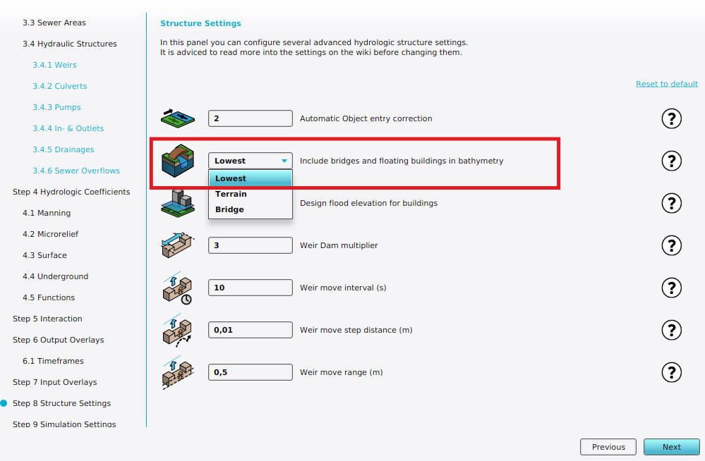
Bridge elevation can be configured in Structure Settings step of a Water Overlay wizard.
| Icon | Attribute | Unit | Range | Description | Default value |
|---|---|---|---|---|---|
| |
BRIDGE_ELEVATION | nominal | 0 to 2 | Specifies the mode by which bridges are include in the elevation model, used for the water calculations. | Lowest |
The water model uses an elevation model for the surface flow calculations. This setting defines how to include bridges in this elevation model:
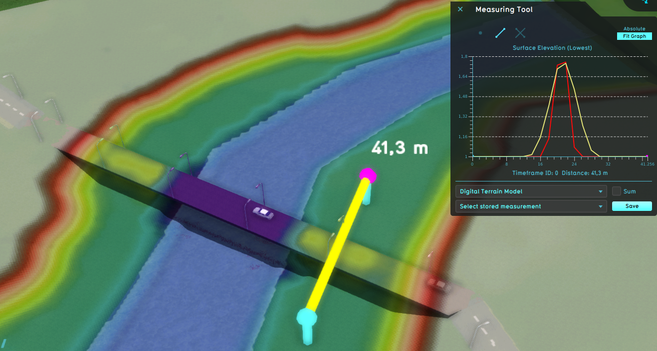
| 0. | Lowest: The lowest elevation point from the terrain elevation (DTM) below bridge is used, when the terrain is water. Otherwise the behavior is similar to Terrain. |
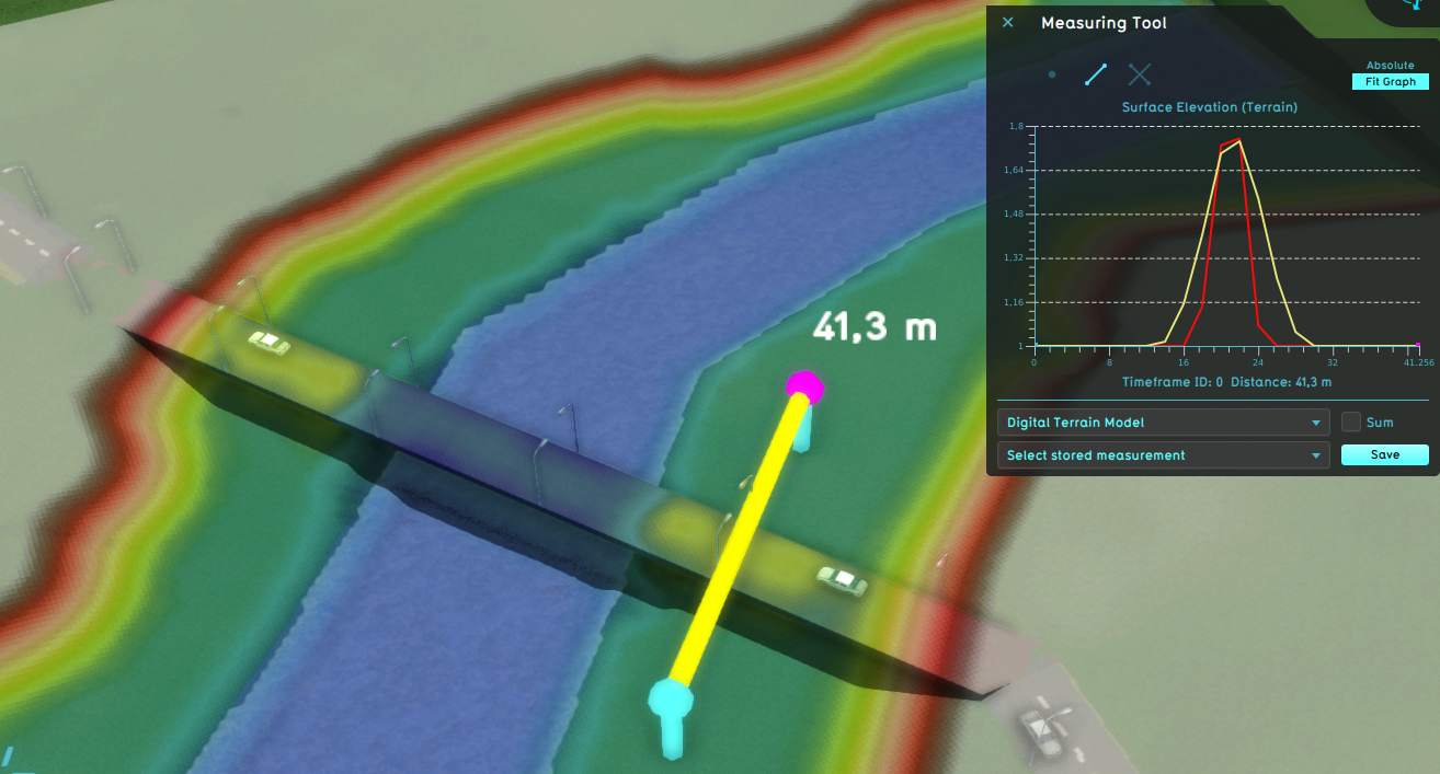
| 1. | Terrain: Under bridges, the terrain elevation (DTM) is used, otherwise the limited surface elevation (DSM) is used. Water can flow under the bridge according to the terrain elevation. |
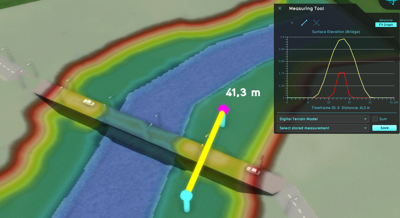
| 2. | Bridge : Use bridge deck as elevation. Bridges and floating buildings are included in the DEM, blocking water flow. |
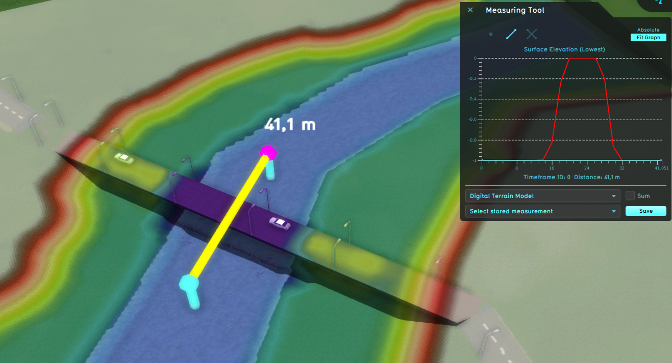
Lowest option measured on water
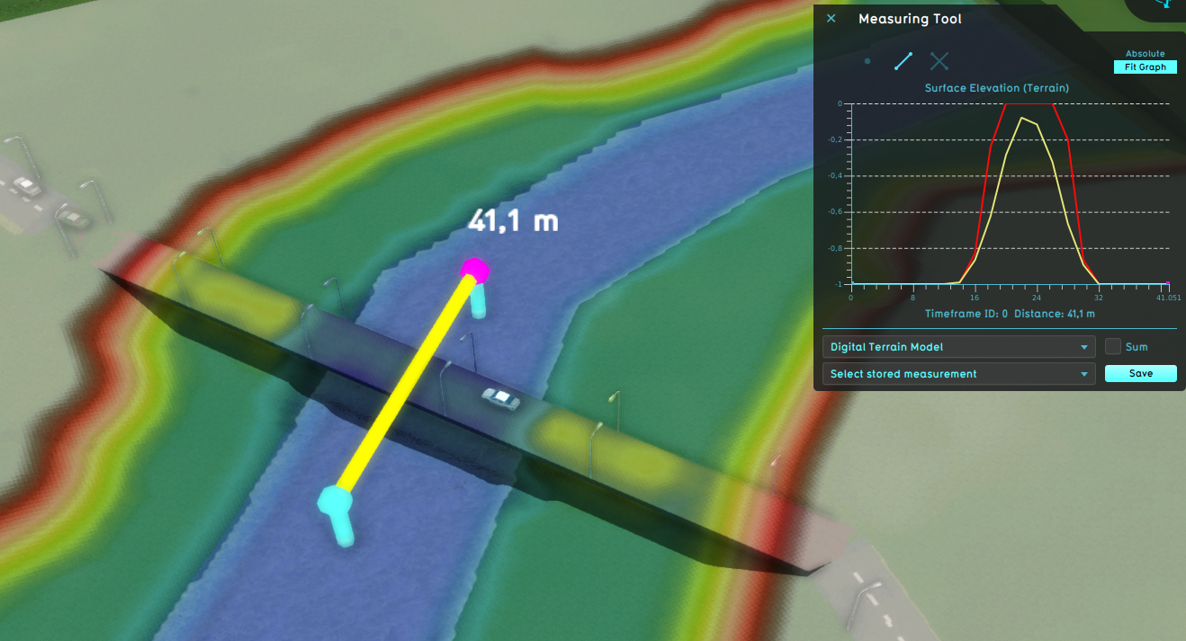
Terrain option measured on water
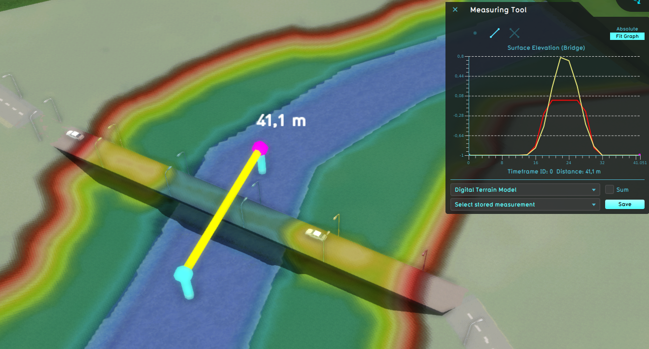
Bridge option measured on water


Lowest option measured on land
Terrain option measured on land
Bridge option measured on land


Notes
- When using Bridge mode, it is still possible to model the flow from one side of a bridge to the other by using a Culvert.
- The surface elevation (DSM) always limits the height of the buildings to the design flood elevation.
How-to's
Videos


- Group
- Model attributes
- Allowed water increase m • Avg shore width m • Avg terrain width m • Avg terrain storage m • Breach measurement distance m • Bridge elevation • Culvert dem threshold m • Design flood elevation m • Extended reconstruction • Ground bottom distance m • Ground bottom pressure m • Ground water • Ground water depth m • Ground watertable with surface • Impact flood threshold m • Impact range m • Increased resolution • Infiltration factor s
- Limit area • Limit rain • Max infiltration m • Max water bottom m • Microrelief storage fraction • Min max elevation • Object entry correction • Prequel surface level relative • Rise rate distance m • Sewer overflow threshold • Shoreline • Show duration flood level m • Stabilizer angle • Start date ms • Surface water • Surface water evaporation factor • Timeframe times • Timeframes • Unsaturated fraction • Weir dam multiplier • Weir move interval s • Weir move range m • Weir move step m
- Related