Elevation (Water Overlay): Difference between revisions
No edit summary |
No edit summary |
||
| Line 11: | Line 11: | ||
{{article end | {{article end | ||
|notes= '''Reconstruction''': No matter which option is configured for the elevation of a water overlay, it still will be reconstructed according to the [[Elevation model (Water Overlay)|requirements of the algorithm]]. | |notes= '''Reconstruction''': No matter which option is configured for the elevation of a water overlay, it still will be reconstructed according to the [[Elevation model (Water Overlay)|requirements of the algorithm]]. | ||
<gallery widths=400px heights=300px> | |||
File:piecewisereconstruction_1d.png|1D linear piecewise reconstruction.Source: Kurganov and Petrova (2007)<ref name="Kurganov2" /> | |||
File:Inundation overlay 04 HWP(2).PNG|2D linear piecewise reconstruction. Source: Horváth et al. (2014)<ref name="Horvath"/> | |||
</gallery> | |||
|howtos= | |howtos= | ||
* [[How to import a GeoTIFF to change the elevation model]] | * [[How to import a GeoTIFF to change the elevation model]] | ||
| Line 24: | Line 28: | ||
* [[Breach (Water Overlay)]] | * [[Breach (Water Overlay)]] | ||
* [[Levee]] | * [[Levee]] | ||
|references= | |||
<references> | |||
<ref name="Kurganov2">Kurganov A, Petrova G (2007) ∙ A Second-Order Well-Balanced Positivity Preserving Central-Upwind Scheme for the Saint-Venant System ∙ found at: http://www.math.tamu.edu/~gpetrova/KPSV.pdf (last visited 2018-06-29)</ref> | |||
<ref name="Horvath">Zsolt Horváth, Jürgen Waser, Rui A. P. Perdigão, Artem Konev and Günter Blöschl (2014) ∙ A two-dimensional numerical scheme of dry/wet fronts for the Saint-Venant system of shallow water equations ∙ found at: http://citeseerx.ist.psu.edu/viewdoc/download?doi=10.1.1.700.7977&rep=rep1&type=pdf ∙ http://visdom.at/media/pdf/publications/Poster.pdf ∙ (last visited 2018-06-29)</ref> | |||
</references> | |||
}} | }} | ||
{{WaterOverlay simulation data nav}} | {{WaterOverlay simulation data nav}} | ||
Revision as of 16:31, 5 March 2024
The elevation model defines the height of the terrain on and in which the hydrology is modeled. Elevation includes the relief on the surface of dry land, but also the height of the stream beds of water bodies.
By default the elevation model will be derived from data sources relevant to the geographical location of the project area. However, especially in water bodies the level of detail of the elevation model may be insufficient. For these situations it's possible to load in a(n additional) GeoTIFF defining elevations, load in a GeoJSON file with water depths, or manually modify the elevation model.
In addition to the elevation model, the height of buildings is also taken into account. Breaches are also embedded into the resulting Digital Surface Model the Water Module uses for its calculations.
During a session, a number of actions can directly affect the terrain height. Actions such as the creation of levees, or the creation of open water, both affect the topography. Placing or removing buildings also affects the terrain height, in terms of where water can flow.
Alternatively, the elevation can be supplied by an other grid overlay, and configured using the Terrain elevation prequel. This can be useful in case you do not want to change the elevation model of your project. However, the prequel overlay must be calculated in advance and must be set to inactive in order for it to be used by the water overlay.
Notes
Reconstruction: No matter which option is configured for the elevation of a water overlay, it still will be reconstructed according to the requirements of the algorithm.
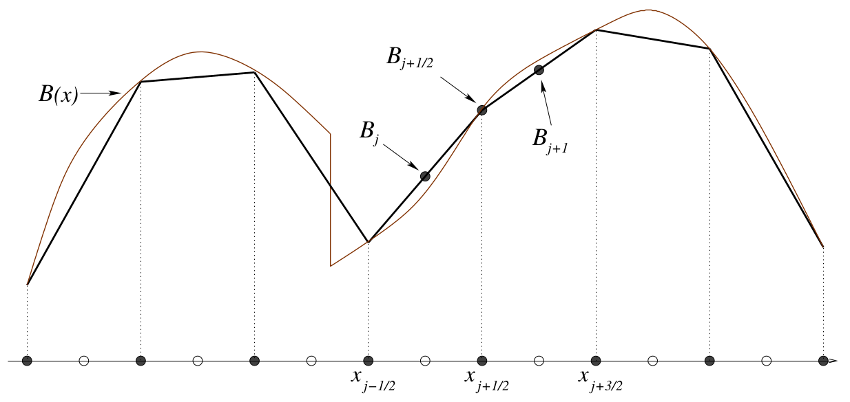
1D linear piecewise reconstruction.Source: Kurganov and Petrova (2007)[1]
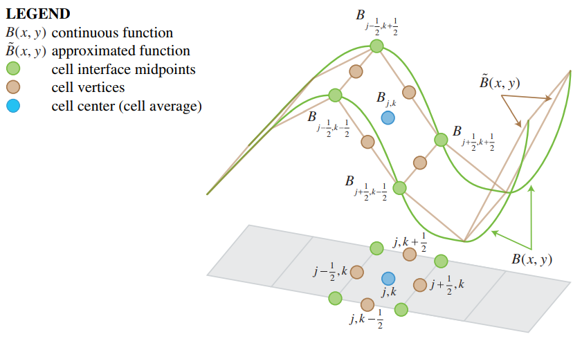
2D linear piecewise reconstruction. Source: Horváth et al. (2014)[2]

.PNG)
How-to's
- How to import a GeoTIFF to change the elevation model
- How to use a Grid Overlay to change the elevation model
- How to import a GeoTIFF of waterway depths
- How to import a GeoJSON to change the elevation model
See also
- Terrain elevation prequel (Water Overlay)
- Elevation model
- Subsidence (Water Overlay)
- Surface model (Water Overlay)
- Elevation model (Water Overlay)
- Breach (Water Overlay)
- Levee
References
- ↑ Kurganov A, Petrova G (2007) ∙ A Second-Order Well-Balanced Positivity Preserving Central-Upwind Scheme for the Saint-Venant System ∙ found at: http://www.math.tamu.edu/~gpetrova/KPSV.pdf (last visited 2018-06-29)
- ↑ Zsolt Horváth, Jürgen Waser, Rui A. P. Perdigão, Artem Konev and Günter Blöschl (2014) ∙ A two-dimensional numerical scheme of dry/wet fronts for the Saint-Venant system of shallow water equations ∙ found at: http://citeseerx.ist.psu.edu/viewdoc/download?doi=10.1.1.700.7977&rep=rep1&type=pdf ∙ http://visdom.at/media/pdf/publications/Poster.pdf ∙ (last visited 2018-06-29)


- Group
- Weather
- Bottom distance • Bottom pressure • Bottom resistance • Ground conductivity • Groundwater datum • Groundwater depth • Manning • Max infiltration • Microrelief • Surface level • Surface u • Surface v • Terrain elevation • Unsaturated fraction
- Elevation
- Elevation
- Related