Geo Data: Difference between revisions
m (Reverted edits by Godelief@tygron.nl (talk) to last revision by Hedi@tygron.com) |
(Undo revision 23368 by Godelief@tygron.nl (talk)) |
||
| Line 1: | Line 1: | ||
{{being_updated}} | |||
{{learned|what Geo Data are|how Geo Data relate to the {{software}}|which Geo-Data sources are used}} | {{learned|what Geo Data are|how Geo Data relate to the {{software}}|which Geo-Data sources are used}} | ||
==What | ==What is Geo data== | ||
Geographical data or geo data are data which have a location component. Almost all data are linked to a location or a place and are, therefore, geo data. Geo data can be, for example, a paper map, a digital web map or just a simple text file with coordinates. Geo datasets | Geographical data or geo data are data which have a location component. Almost all data are linked to a location or a place and are, therefore, geo data. Geo data can be, for example, a paper map, a digital web map or just a simple text file with coordinates. Geo datasets is either '''vector data''' (that is, features which are points, lines or polygons) or '''raster data''' (that is, data in grid cells). The features in vector data can have multiple attributes with values. Raster data mostly consist of a value and a color. | ||
==How do Geo | ==How do Geo datasets relate to the {{software}}== | ||
[[File:Generate_3D_world_databases.png|Load data from databases|400px|left]] | [[File:Generate_3D_world_databases.png|Load data from databases|400px|left]] | ||
The {{software}} uses | The {{software}} uses Geo data (vector and raster data) for creating the [[3D World|3D-model world]]. For this, the {{software}} automatically connects to (Open) Datasets (see image), based on the availability of the data for the chosen location of the project. For example the Base Registers in the Netherlands and Open Street Maps worldwide. For a whole overview of all the connected datasets, see this [[Project_Sources#Sources_connected_to_the_Tygron_Platform|table]]. | ||
To add missing Geo data | A principle that generally applies: if your 3D World lacks certain information, then it is not available in the used datasets. <br> For more information on which data is used for your generating your project, see the [[Project_Sources#SMore_information_on_which_sources_are_used|project sources]] page. | ||
To add missing Geo data you can add additional Geo data manually (see below for options). | |||
<br clear=all> | <br clear=all> | ||
== | ==When to use your own data== | ||
* The project takes place in a location for which there are no data sources available to create the project | |||
* The default data sources are not accurate or up-to-date enough | |||
* The default datasets are not detailed enough | |||
* To do a more extendend analysis in the {{software}} | |||
* To use in combination with an Excel Indicator or Panel | |||
* For creating more overview in your project, for example by highlighting areas | |||
In these situations, it might be useful to overwrite or import data by the user. | |||
==Which data can be uploaded to the {{software}}== | |||
Almost all data can be imported in the {{software}}, as long as the data is about a specific location and has a geometry. Thus basically when the data is geo data. | |||
This means that also [[Spatial plans|spatial plans]] can be imported in the {{software}}. | |||
==How to import Geo data== | |||
There are different methods for importing Geo Data.The method to choose is based on how you have your data available, as vector or raster data. | |||
====Vector==== | |||
With the [[Geo_Data_Wizard|Geo data wizard]] you can easily import vector data. The wizard also helps you to transform your data to the proper format for importing. The following requirements for vector data apply: | |||
# Geo Data in the {{software}} are always polygons. Line and point features are not allowed by the {{software}}. The data wizards helps you by buffering the line and point features to polygons. | |||
# All desired attributes must be numerical, so that they can be loaded as valid [[attribute]] values. Non-numeric attributes are ignored when attempting to load them as attributes. | |||
There are different import methods. These methods can be divided into two: uploading data from a file to the Tygron Platform and the other is downloading data through an URL to the Tygron Platform. The different methods are: | |||
# with a [[GeoJSON]] file | |||
# through a [[WFS|Web Feature Service (WFS)]] | |||
# through a [[CSW|Catalogue Service for the Web (CSW)]] | |||
====Raster==== | |||
# through a [[WMS|Web Map Service (WMS)]]. | |||
# as a [[Geotiff_(Overlay)|Geotiff overlay]] | |||
==How to export Geo data== | |||
====Export vector data==== | |||
The components that make up the 3D world can be exported as 2D vector data in [[GeoJSON]] format. With these data, further/other calculations or analysis can be done in for example GIS software. | |||
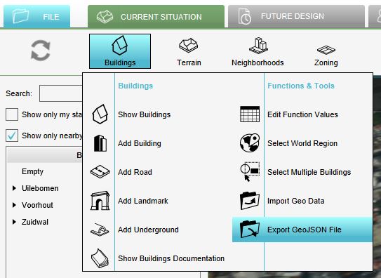
In the Current Situation tab, each of the following menus has an export GeoJSON option: | |||
*[[Buildings]] | |||
*[[Terrains]] | |||
*[[Neighborhoods]] | |||
*[[Zoning]] | |||
*[[Plots]] | |||
*[[Areas]] | |||
*[[Network]] | |||
<br> | |||
{{Editor steps|title=export components of the 3D world|Hover over the desired menu you want to export objects from.|Select Export GeoJSON file|Choose additional options to make a selection of the to be exported data or for export all, click on the Export button.}} | |||
<gallery> | |||
File:Export_geojson_file.JPG|Export GeoJSON button in the Buildings menu. | |||
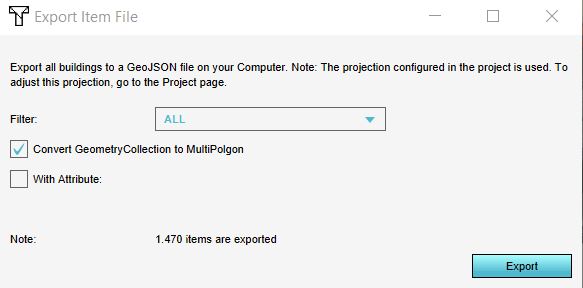
File:Export_options.JPG|Make a selection based on category and/or attribute or export all objects by clicking on the Export button. | |||
</gallery> | |||
In the Export Item File panel that will show up, different options for exporting are available: | |||
* Objects from a certain category/type (only for the [[Buildings]] and [[Terrain|Terrains]] can be exported by selecting the desired category/type). | |||
* Only objects that have a certain attribute can be exported by checking the ''With Attribute'' option and selecting the desired attribute. For example if you only want [[Culvert_(Water_Overlay)|culverts]], you can select the category ''Underground'' (since the function culverts belongs to the category Underground) and check the ''With Attribute'' option and select the attribute name ''CULVERT_DIAMETER'' for example. This will export culverts, since only these objects have this attribute in common. | |||
<br clear=all> | |||
====Export raster data==== | |||
[[Grid_Overlay|Grid overlays]] can be exported as a GeoTIFF or ASCII file. With the GeoTIFF file, calculations from for example the [[Water_Overlay|Water overlay]] can be exported to be further processed for analysis in GIS software. For exporting the grid overlays, take also note of the [[Grid_Overlay#Grid_size|grid size]]. The smaller the grid size, the more accurate the exported GeoTIFF is. | |||
<br> | |||
<br> | |||
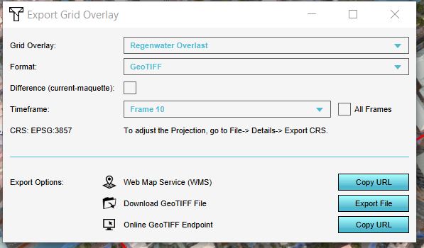
{{Editor steps|title=export grid overlay calculation results |Select any grid overlay in the editor.|On the [[right panel]], select "Export Grid File".|Choose the overlay, format and click on the Export button.}} | |||
| | <gallery> | ||
File:Select_grid_overlay.jpg|Select a grid overlay | |||
File:Geotiff_export.jpg|Select "Export Grid File" | |||
File:Export_grid_options.JPG|Choose the desired overlay to export, if applicable the difference overlay and/or timeframe and the desired format. | |||
</gallery> | |||
| | In the Export Grid File panel that will show up, different options for exporting are available: | ||
*If in a [[Test_Run|test run]] the option ''Export difference (current and maquette)'' is selected, the difference in results between the maquette state and the current state will be exported. If you checked this option outside of the test run, or did not do any [[Action|Actions]], the exported dataset will consist no difference. | |||
* For the [[Water_Overlay|water overlays]], it is possible to export a dataset at a certain [[Timeframes_model_attribute_(Water_Overlay)|timeframe]], by selecting the ID of the timeframe. Keep in mind that the ID of the timeframe counts up from 0. Thus if you have 10 timeframes in the overlay, the timeframes IDs range from 0 to 9. | |||
<br clear=all> | |||
| | |||
| | |||
| | |||
| | |||
| | |||
| | |||
| | |||
| | |||
| | |||
| | |||
| | |||
| | |||
Revision as of 14:46, 1 May 2019
What is Geo data
Geographical data or geo data are data which have a location component. Almost all data are linked to a location or a place and are, therefore, geo data. Geo data can be, for example, a paper map, a digital web map or just a simple text file with coordinates. Geo datasets is either vector data (that is, features which are points, lines or polygons) or raster data (that is, data in grid cells). The features in vector data can have multiple attributes with values. Raster data mostly consist of a value and a color.
How do Geo datasets relate to the Tygron Platform

The Tygron Platform uses Geo data (vector and raster data) for creating the 3D-model world. For this, the Tygron Platform automatically connects to (Open) Datasets (see image), based on the availability of the data for the chosen location of the project. For example the Base Registers in the Netherlands and Open Street Maps worldwide. For a whole overview of all the connected datasets, see this table.
A principle that generally applies: if your 3D World lacks certain information, then it is not available in the used datasets.
For more information on which data is used for your generating your project, see the project sources page.
To add missing Geo data you can add additional Geo data manually (see below for options).
When to use your own data
- The project takes place in a location for which there are no data sources available to create the project
- The default data sources are not accurate or up-to-date enough
- The default datasets are not detailed enough
- To do a more extendend analysis in the Tygron Platform
- To use in combination with an Excel Indicator or Panel
- For creating more overview in your project, for example by highlighting areas
In these situations, it might be useful to overwrite or import data by the user.
Which data can be uploaded to the Tygron Platform
Almost all data can be imported in the Tygron Platform, as long as the data is about a specific location and has a geometry. Thus basically when the data is geo data. This means that also spatial plans can be imported in the Tygron Platform.
How to import Geo data
There are different methods for importing Geo Data.The method to choose is based on how you have your data available, as vector or raster data.
Vector
With the Geo data wizard you can easily import vector data. The wizard also helps you to transform your data to the proper format for importing. The following requirements for vector data apply:
- Geo Data in the Tygron Platform are always polygons. Line and point features are not allowed by the Tygron Platform. The data wizards helps you by buffering the line and point features to polygons.
- All desired attributes must be numerical, so that they can be loaded as valid attribute values. Non-numeric attributes are ignored when attempting to load them as attributes.
There are different import methods. These methods can be divided into two: uploading data from a file to the Tygron Platform and the other is downloading data through an URL to the Tygron Platform. The different methods are:
- with a GeoJSON file
- through a Web Feature Service (WFS)
- through a Catalogue Service for the Web (CSW)
Raster
- through a Web Map Service (WMS).
- as a Geotiff overlay
How to export Geo data
Export vector data
The components that make up the 3D world can be exported as 2D vector data in GeoJSON format. With these data, further/other calculations or analysis can be done in for example GIS software. In the Current Situation tab, each of the following menus has an export GeoJSON option:
- Hover over the desired menu you want to export objects from.
- Select Export GeoJSON file
- Choose additional options to make a selection of the to be exported data or for export all, click on the Export button.
Export GeoJSON button in the Buildings menu.
Make a selection based on category and/or attribute or export all objects by clicking on the Export button.


In the Export Item File panel that will show up, different options for exporting are available:
- Objects from a certain category/type (only for the Buildings and Terrains can be exported by selecting the desired category/type).
- Only objects that have a certain attribute can be exported by checking the With Attribute option and selecting the desired attribute. For example if you only want culverts, you can select the category Underground (since the function culverts belongs to the category Underground) and check the With Attribute option and select the attribute name CULVERT_DIAMETER for example. This will export culverts, since only these objects have this attribute in common.
Export raster data
Grid overlays can be exported as a GeoTIFF or ASCII file. With the GeoTIFF file, calculations from for example the Water overlay can be exported to be further processed for analysis in GIS software. For exporting the grid overlays, take also note of the grid size. The smaller the grid size, the more accurate the exported GeoTIFF is.
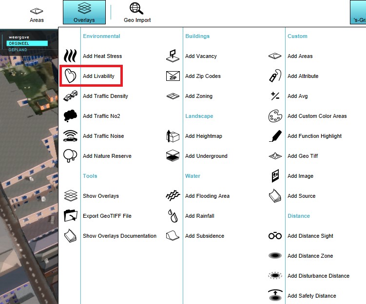
- Select any grid overlay in the editor.
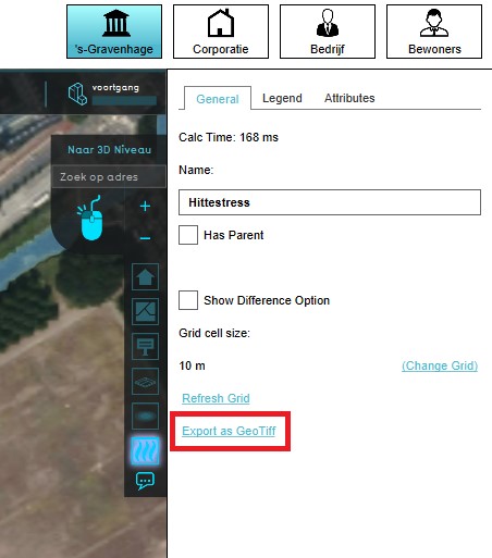
- On the right panel, select "Export Grid File".
- Choose the overlay, format and click on the Export button.
Select a grid overlay
Select "Export Grid File"
Choose the desired overlay to export, if applicable the difference overlay and/or timeframe and the desired format.


In the Export Grid File panel that will show up, different options for exporting are available:
- If in a test run the option Export difference (current and maquette) is selected, the difference in results between the maquette state and the current state will be exported. If you checked this option outside of the test run, or did not do any Actions, the exported dataset will consist no difference.
- For the water overlays, it is possible to export a dataset at a certain timeframe, by selecting the ID of the timeframe. Keep in mind that the ID of the timeframe counts up from 0. Thus if you have 10 timeframes in the overlay, the timeframes IDs range from 0 to 9.