Traffic NO2 Overlay: Difference between revisions
m (Rudolf@tygron.nl moved page Traffic NO2 (Overlay) to Traffic NO2 Overlay over redirect) |
No edit summary |
||
| Line 1: | Line 1: | ||
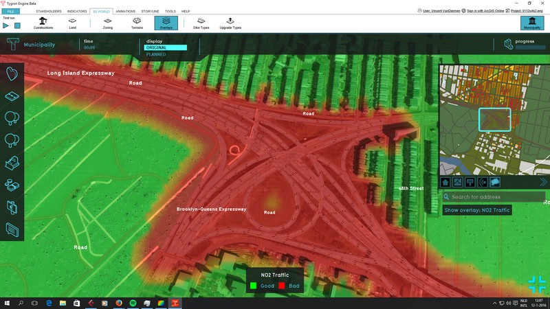
The Traffic NO2 Overlay is | [[File:Traffic_NO2-Overlay.jpg|thumb|right|Optional Traffic NO2 (Air polution effect) overlay]] | ||
The Traffic NO2 Overlay is a [[Grid Overlay]] which computes the impact of traffic air pollution (in μg/m³ NO2) for any given location in the [[3D World]]. The calculation takes into account the amounts- and types of traffic, and the distance from the source of emission. | |||
The Overlay only takes into account NO2 emissions from traffic. Other sources of emissions (such as air traffic of factories) are explicitly excluded. | |||
The | {{clear}} | ||
==Configuration== | |||
{{main|Model attributes (Traffic NO2 Overlay)}} | |||
The Traffic NO2 Overlay has a number of options which allow it to be configured as desired. A [[Traffic NO2 Overlay Wizard|configuration wizard]] is available. | |||
The following aspects can be configured: | |||
* Emissions per vehicle type both in motion and in traffic jam | |||
* Constants for road-based dilution factors | |||
==Calculation== | |||
{{main|Traffic NO2 formula (Traffic NO2 Overlay)}} | |||
The Traffic NO2 Overlay performs its calculations based on the [[Model attributes (Traffic NO2 Overlay)|Overlay's Attributes]], and the [[Construction attributes (Traffic Overlay)|Attributes of roads]] present in the [[3D World]]. | |||
==Results== | |||
The following result types are available as output from the traffic NO2 calculations: | |||
{{article end | |||
|howtos= | |||
* [[How to add and remove an Overlay]] | * [[How to add and remove an Overlay]] | ||
* [[How to edit an overlay legend| | * [[How to edit an overlay legend]] | ||
|references= | |||
{{ | * The overlay calculations are based on Standard Calculation Method 1 (SRM1) as defined by the dutch government: [http://wetten.overheid.nl/BWBR0022817/2013-01-01#Bijlage1 wetten.overheid.nl] | ||
}} | |||
{{Overlay nav}} | |||
Revision as of 11:50, 11 February 2022
The Traffic NO2 Overlay is a Grid Overlay which computes the impact of traffic air pollution (in μg/m³ NO2) for any given location in the 3D World. The calculation takes into account the amounts- and types of traffic, and the distance from the source of emission.
The Overlay only takes into account NO2 emissions from traffic. Other sources of emissions (such as air traffic of factories) are explicitly excluded.
Configuration
- Main article: Model attributes (Traffic NO2 Overlay)
The Traffic NO2 Overlay has a number of options which allow it to be configured as desired. A configuration wizard is available.
The following aspects can be configured:
- Emissions per vehicle type both in motion and in traffic jam
- Constants for road-based dilution factors
Calculation
- Main article: Traffic NO2 formula (Traffic NO2 Overlay)
The Traffic NO2 Overlay performs its calculations based on the Overlay's Attributes, and the Attributes of roads present in the 3D World.
Results
The following result types are available as output from the traffic NO2 calculations:
How-to's
References
- The overlay calculations are based on Standard Calculation Method 1 (SRM1) as defined by the dutch government: wetten.overheid.nl
