Traffic NO2 Overlay: Difference between revisions
No edit summary |
|||
| (76 intermediate revisions by 9 users not shown) | |||
| Line 1: | Line 1: | ||
[[File:Traffic_NO2-Overlay.jpg|thumb|right|Traffic NO2 Overlay]] | |||
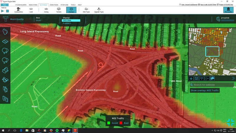
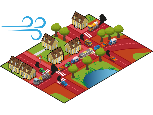
The Traffic NO2 Overlay is a [[Grid Overlay]] which computes the impact of traffic air pollution (in μg/m³ NO2) for any given location in the [[project]]. The calculation takes into account the amount of traffic per [[type]] and the distance from the source of emission. It also takes into account [[Building|object]]s and [[Elevation model|terrain features]] which would hinder the travel of particles. | |||
The Overlay only takes into account NO2 emissions from traffic. Other sources of emissions (such as air traffic of factories) are explicitly excluded. | |||
The Overlay implements SRM1{{ref|srm1}}, which is only applicable for urban environments. | |||
[[File: | [[File:Traffic_NO2-Overlay-model.png|thumb|left|Traffic NO2 Model]] | ||
{{clear}} | |||
== | ==Configuration== | ||
{{main|Model attributes (Traffic NO2 Overlay)}} | |||
The Traffic NO2 Overlay has a number of options which allow it to be configured as desired. A [[Traffic NO2 Overlay Wizard|configuration wizard]] is available. | |||
The following aspects can be configured: | |||
* Base concentrations of NO2 and NOx | |||
* Emissions per vehicle type both in motion and in traffic jam | |||
* Constants for road-based dilution factors | |||
* The hour(s) of the day to perform the calculation for | |||
===Traffic=== | |||
Traffic intensities for each type of traffic can be based on one of the following: | |||
* The [[Building attributes (Traffic NO2 Overlay)|Attributes of roads]] present in the [[project]]. | |||
* [[Prequels (Traffic NO2 Overlay)|Prequel Overlay]]s which define respective traffic intensities on a grid. | |||
The traffic intensities can be defined as either a single value or as 24 hours, with each value corresponding to each hour of the day. The intensity used for the calculation is then defined by the [[Hours (Traffic NO2 Overlay)|HOURS model Attribute]]. | |||
{{ | ==Calculation== | ||
{{main|Traffic NO2 formula (Traffic NO2 Overlay)}} | |||
The Traffic NO2 Overlay performs its calculations based on the [[Model attributes (Traffic NO2 Overlay)|Overlay's Attributes]], the presence of [[Building|trees]], and the [[Building attributes (Traffic NO2 Overlay)|Attributes of roads]] present in the [[project]]. The calculations follow the standard rekenmethode 1 (SRM 1){{ref|srm1}}. | |||
==Results== | |||
The following result types are available as output from the traffic NO2 calculations: | |||
{{result types|suppresscategory=true|allowselflinks=true| | |||
{{:Concentration result type (Traffic NO2 Overlay)}} | |||
{{:Emission no2 result type (Traffic NO2 Overlay)}} | |||
{{:Emission nox result type (Traffic NO2 Overlay)}} | |||
{{:Treefactor result type (Traffic NO2 Overlay)}} | |||
{{:Trees result type (Traffic NO2 Overlay)}} | |||
}} | |||
{{article end | |||
|notes= | |||
* The Overlay calculations are based on Standard Calculation Method 1 (SRM1) as defined by the dutch government.{{ref|srm1}}. | |||
|howtos= | |||
* [[How to add and remove an Overlay]] | |||
* [[How to edit an overlay legend]] | |||
* [[How to add a static traffic model]] | |||
* [[How to add a static grid-based traffic model]] | |||
* [[How to add traffic data unaligned with roads]] | |||
* [[How to add a dynamic traffic model]] | |||
|references= | |||
<references> | |||
{{ref|srm1 | |||
|name=SRM1 | |||
|author= | |||
|page= | |||
|source=Regeling beoordeling luchtkwaliteit 2007, Bijlage I | |||
|link=http://wetten.overheid.nl/BWBR0022817/2013-01-01#Bijlage1 | |||
|lastvisit=16-02-2022 | |||
}} | |||
</references> | |||
}} | |||
{{TrafficNO2Overlay nav}} | |||
{{Overlay nav}} | |||
Latest revision as of 08:27, 29 February 2024

The Traffic NO2 Overlay is a Grid Overlay which computes the impact of traffic air pollution (in μg/m³ NO2) for any given location in the project. The calculation takes into account the amount of traffic per type and the distance from the source of emission. It also takes into account objects and terrain features which would hinder the travel of particles.
The Overlay only takes into account NO2 emissions from traffic. Other sources of emissions (such as air traffic of factories) are explicitly excluded.
The Overlay implements SRM1[1], which is only applicable for urban environments.

Configuration
- Main article: Model attributes (Traffic NO2 Overlay)
The Traffic NO2 Overlay has a number of options which allow it to be configured as desired. A configuration wizard is available.
The following aspects can be configured:
- Base concentrations of NO2 and NOx
- Emissions per vehicle type both in motion and in traffic jam
- Constants for road-based dilution factors
- The hour(s) of the day to perform the calculation for
Traffic
Traffic intensities for each type of traffic can be based on one of the following:
- The Attributes of roads present in the project.
- Prequel Overlays which define respective traffic intensities on a grid.
The traffic intensities can be defined as either a single value or as 24 hours, with each value corresponding to each hour of the day. The intensity used for the calculation is then defined by the HOURS model Attribute.
Calculation
- Main article: Traffic NO2 formula (Traffic NO2 Overlay)
The Traffic NO2 Overlay performs its calculations based on the Overlay's Attributes, the presence of trees, and the Attributes of roads present in the project. The calculations follow the standard rekenmethode 1 (SRM 1)[1].
Results
The following result types are available as output from the traffic NO2 calculations:
| Icon | Result type | Unit | Mode | Description |
|---|---|---|---|---|
| CONCENTRATION | μg/m3 | The concentration of NO2-equivalent pollution as a result of traffic. | ||
| EMISSION_NO2 | μg/m3 | The calculated emissions of NO2 due to traffic. | ||
| EMISSION_NOX | μg/m3 | The calculated emissions of NOX due to traffic. | ||
| TREEFACTOR | factor | The presence of trees (within 30 meters) as a fraction and converted to a factor between 1 and 1.5. | ||
| TREES | boolean | The presence of trees in any given location specifically. |
Notes
- The Overlay calculations are based on Standard Calculation Method 1 (SRM1) as defined by the dutch government.[1].
How-to's
- How to add and remove an Overlay
- How to edit an overlay legend
- How to add a static traffic model
- How to add a static grid-based traffic model
- How to add traffic data unaligned with roads
- How to add a dynamic traffic model
References
- ↑ 1.0 1.1 1.2 SRM1 ∙ Regeling beoordeling luchtkwaliteit 2007, Bijlage I ∙ Found at: http://wetten.overheid.nl/BWBR0022817/2013-01-01#Bijlage1 ∙ (last visited: 16-02-2022)