Industrial runoff (Indicator): Difference between revisions
No edit summary |
|||
| (15 intermediate revisions by 6 users not shown) | |||
| Line 1: | Line 1: | ||
The industrial runoff indicator calculates how much industry is within 20 meters of a body of water. This allows some insight into the risk of water being contaminated by industrial processes due to their proximity to water bodies. This insight into the industrial runoff potential is useful when dealing with use-cases concerning: | |||
The industrial runoff indicator calculates how much industry is | |||
* Spatial quality of life | * Spatial quality of life | ||
* Biodiversity and nature | * Biodiversity and nature | ||
* Pollution and waste | * Pollution and waste | ||
This Excel indicator can be downloaded from the [ | This Excel indicator can be downloaded from the Public [[GeoShare]]. Read on to find out more about the indicator's calculation method and how to set it up in your project. | ||
===Indicator panel=== | ===Indicator panel=== | ||
| Line 18: | Line 15: | ||
===Calculation=== | ===Calculation=== | ||
The indicator will calculate per neighborhood the amount of water with industry nearby. This can also be industry in another neighborhood but close to the water of the neighborhood in question. | The indicator will calculate per neighborhood the amount of water with industry nearby. This can also be industry in another neighborhood but close to the water of the neighborhood in question. | ||
Industry is considered near water when it is within 20 meters of the water. This determination is made by computing a buffer of 20 meters around the water, and counting all the industrial lotsize within that buffered area. | |||
The indicator performs the following calculation | The indicator performs the following calculation | ||
* Determine amount of water in the neighborhood | * Determine amount of water in the neighborhood | ||
* Determine the lotsize of industry-type constructions within 20 meters of the neighborhood's water | * Determine the lotsize of industry-type constructions within 20 meters of the neighborhood's water | ||
* Determine the ratio of water and the amount of industry | * Determine the ratio of water and the amount of industry within 20 meters of the neighborhood's water | ||
* Scale the resulting ratio to a range of 0% to 10%. | * Scale the resulting ratio to a range of 0% to 10%. | ||
* Invert the ratio to compute the score (a lower ratio is a better score). | * Invert the ratio to compute the score (a lower ratio is a better score). | ||
| Line 28: | Line 26: | ||
===Score=== | ===Score=== | ||
The total score is determined by the ratio of industry near water over the total amount of water. The lower the ratio, the better. | The total score is determined by the ratio of industry near water over the total amount of water. The lower the ratio, the better. | ||
For legibility, when used with absolute score, a ratio of 1:10 equals a score of 0%. | For legibility, when used with absolute score, a ratio of 1:10 equals a score of 0%. | ||
| Line 34: | Line 31: | ||
===Additional configurations=== | ===Additional configurations=== | ||
The indicator can also be loaded in as a panel. When opened, it will highlight the locations where industry is close to the water. | The indicator can also be loaded in as a panel. When opened, it will highlight the locations where industry is close to the water. | ||
{{Indicator nav}} | |||
[[Category:Public GeoShare]] | |||
[[Category: | |||
Latest revision as of 16:01, 2 February 2023
The industrial runoff indicator calculates how much industry is within 20 meters of a body of water. This allows some insight into the risk of water being contaminated by industrial processes due to their proximity to water bodies. This insight into the industrial runoff potential is useful when dealing with use-cases concerning:
- Spatial quality of life
- Biodiversity and nature
- Pollution and waste
This Excel indicator can be downloaded from the Public GeoShare. Read on to find out more about the indicator's calculation method and how to set it up in your project.
Indicator panel

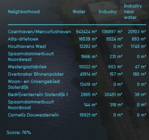
The indicator panel shows the following information:
- The amount of industry in a neighborhood
- The amount of water in a neighborhood
- The amount of industry which is near water in that neighborhood. (Including industry which is in another neighborhood.)
Calculation
The indicator will calculate per neighborhood the amount of water with industry nearby. This can also be industry in another neighborhood but close to the water of the neighborhood in question. Industry is considered near water when it is within 20 meters of the water. This determination is made by computing a buffer of 20 meters around the water, and counting all the industrial lotsize within that buffered area.
The indicator performs the following calculation
- Determine amount of water in the neighborhood
- Determine the lotsize of industry-type constructions within 20 meters of the neighborhood's water
- Determine the ratio of water and the amount of industry within 20 meters of the neighborhood's water
- Scale the resulting ratio to a range of 0% to 10%.
- Invert the ratio to compute the score (a lower ratio is a better score).
Score
The total score is determined by the ratio of industry near water over the total amount of water. The lower the ratio, the better.
For legibility, when used with absolute score, a ratio of 1:10 equals a score of 0%.
Additional configurations
The indicator can also be loaded in as a panel. When opened, it will highlight the locations where industry is close to the water.