Geo Option: Difference between revisions
No edit summary |
No edit summary |
||
| (One intermediate revision by the same user not shown) | |||
| Line 15: | Line 15: | ||
In the template settings screen, the data sources that should be used by default when using this template, can be set. For example AHN3 can be selected so that the AHN3 is always used when creating a project based on that template. Changes made are stored in [[Geo Option]] items. | In the template settings screen, the data sources that should be used by default when using this template, can be set. For example AHN3 can be selected so that the AHN3 is always used when creating a project based on that template. Changes made are stored in [[Geo Option]] items. | ||
==Geo Options== | |||
{|class=wikitable | |||
!Name | |||
!Default Value | |||
!Description | |||
|- | |||
|NL_BGT | |||
|true | |||
|BGT (dataset not complete, more details in roads, water, streetobjects, trees) | |||
|- | |||
|HEIGHTMAP_RESOLUTION | |||
|NORMAL | |||
|DEM Resolution | |||
|- | |||
|SATELLITE_RESOLUTION | |||
|HIGH | |||
|Satellite Background Resolution | |||
|- | |||
|RISK_ASSESSMENT | |||
|false | |||
|Risk Assessment (detect e.g. dangerous objects like LPG stations) | |||
|- | |||
|AGRICULTURE | |||
|true | |||
|Agriculture (crop fields, grassland, etc) | |||
|- | |||
|UNDERGROUND | |||
|true | |||
|Underground (soil type) | |||
|- | |||
|OWNERSHIP | |||
|true | |||
|Ownership (cadastral data) | |||
|- | |||
|WATER | |||
|true | |||
|Water (rivers, canals, etc) | |||
|- | |||
|ZONING | |||
|false | |||
|Zoningplan (limitations to buildings) | |||
|- | |||
|NL_AHN | |||
|AHN4 | |||
|Dutch AHN version | |||
|- | |||
|NL_MIN_TREE_HEIGHT | |||
|5 | |||
|Tree Height from AHN Surface (min value in meters) | |||
|- | |||
|NL_MAX_TREE_HEIGHT | |||
|50 | |||
|Tree Height from AHN Surface (max value in meters) | |||
|- | |||
|DTM_DSM_THRESHOLDS | |||
|0.0 0.0 0.0 | |||
|Apply DSM to DTM Thresholds for Land, Roads and Other. | |||
|- | |||
|WORLD_WATER | |||
|OSM | |||
|Water (rivers, canals, etc) | |||
|- | |||
|OSM_ROADS | |||
|true | |||
|Use OpenStreetMap for Roads | |||
|- | |||
|OSM_BUILDINGS | |||
|true | |||
|Use OpenStreetMap for Buildings | |||
|- | |||
|OSM_LANDUSE | |||
|true | |||
|Use OpenStreetMap for Landuse | |||
|- | |||
|OSM_NEIGHBORHOODS | |||
|true | |||
|Use OpenStreetMap for Neighborhoods | |||
|- | |||
|IMWA | |||
|true | |||
|IMWA Water System constructions such as culverts | |||
|- | |||
|BAG3D_GEOMETRIES | |||
|false | |||
|Use 3D BAG by tudelft3d for Building Geometries | |||
|- | |||
|I3S_GEOMETRIES | |||
|false | |||
|Use I3S Scenelayer for Building Geometries (BETA) | |||
|- | |||
|NL_TRAFFIC_INWEVA | |||
|true | |||
|INWEVA 24h Data | |||
|- | |||
|NL_TRAFFIC_NSL | |||
|true | |||
|NSL Monitoring | |||
|- | |||
|NL_TRAFFIC_NSL_CONVERSION | |||
|0.051 | |||
|NSL Conversion from day to hour values (default 1.22 / 24) | |||
|- | |||
|NL_TRAFFIC_INFOMIL | |||
|true | |||
|InfoMil Ruleset | |||
|- | |||
|NL_ENERGY_LABEL | |||
|true | |||
|Address Energy Labels | |||
|- | |||
|INTEREST_AREA_MARGIN | |||
|500 | |||
|Default margin around Area of Interest on file drop | |||
|- | |||
|TREES | |||
|true | |||
|Default Trees from various Sources | |||
|} | |||
{{article end| | {{article end| | ||
|seealso= | |seealso= | ||
* [[Advanced options (New Project Wizard)]] | * [[Advanced options (New Project Wizard)]] | ||
* [[Template Project]] | * [[Template Project]] | ||
|howtos=*[[How to disable Tree placements from default Sources on Project creation]] | |||
}} | }} | ||
{{editor tools nav}} | {{editor tools nav}} | ||
Latest revision as of 12:40, 26 March 2025

Geo Options are items that store particular settings used by the Tygron Engine when generating a new project.
New Project Wizard

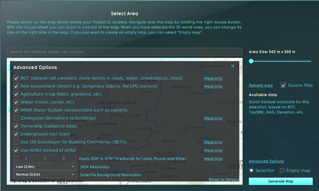
When choosing the location of the project area during the New Project Wizard, in the second panel of the wizard, the default mode for data selection is Selection. When this option is checked, the Tygron Engine will acquire datasets from a variety of open datasets that are linked to the selected area. Find an overview on which data is used to create a new 3D model on the Project Sources page. The Advanced Options panel can be found above the selection option. When you open this panel the list of a few of the open datasets is displayed. You can choose to include or excluded specific data sources in your project creation.
Editor

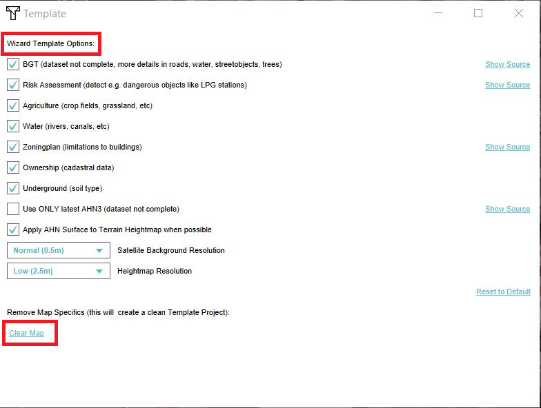
In the template settings screen, the data sources that should be used by default when using this template, can be set. For example AHN3 can be selected so that the AHN3 is always used when creating a project based on that template. Changes made are stored in Geo Option items.
Geo Options
| Name | Default Value | Description |
|---|---|---|
| NL_BGT | true | BGT (dataset not complete, more details in roads, water, streetobjects, trees) |
| HEIGHTMAP_RESOLUTION | NORMAL | DEM Resolution |
| SATELLITE_RESOLUTION | HIGH | Satellite Background Resolution |
| RISK_ASSESSMENT | false | Risk Assessment (detect e.g. dangerous objects like LPG stations) |
| AGRICULTURE | true | Agriculture (crop fields, grassland, etc) |
| UNDERGROUND | true | Underground (soil type) |
| OWNERSHIP | true | Ownership (cadastral data) |
| WATER | true | Water (rivers, canals, etc) |
| ZONING | false | Zoningplan (limitations to buildings) |
| NL_AHN | AHN4 | Dutch AHN version |
| NL_MIN_TREE_HEIGHT | 5 | Tree Height from AHN Surface (min value in meters) |
| NL_MAX_TREE_HEIGHT | 50 | Tree Height from AHN Surface (max value in meters) |
| DTM_DSM_THRESHOLDS | 0.0 0.0 0.0 | Apply DSM to DTM Thresholds for Land, Roads and Other. |
| WORLD_WATER | OSM | Water (rivers, canals, etc) |
| OSM_ROADS | true | Use OpenStreetMap for Roads |
| OSM_BUILDINGS | true | Use OpenStreetMap for Buildings |
| OSM_LANDUSE | true | Use OpenStreetMap for Landuse |
| OSM_NEIGHBORHOODS | true | Use OpenStreetMap for Neighborhoods |
| IMWA | true | IMWA Water System constructions such as culverts |
| BAG3D_GEOMETRIES | false | Use 3D BAG by tudelft3d for Building Geometries |
| I3S_GEOMETRIES | false | Use I3S Scenelayer for Building Geometries (BETA) |
| NL_TRAFFIC_INWEVA | true | INWEVA 24h Data |
| NL_TRAFFIC_NSL | true | NSL Monitoring |
| NL_TRAFFIC_NSL_CONVERSION | 0.051 | NSL Conversion from day to hour values (default 1.22 / 24) |
| NL_TRAFFIC_INFOMIL | true | InfoMil Ruleset |
| NL_ENERGY_LABEL | true | Address Energy Labels |
| INTEREST_AREA_MARGIN | 500 | Default margin around Area of Interest on file drop |
| TREES | true | Default Trees from various Sources |
How-to's
See also